In the previous posts, we have considered some fairly "heavy" material about the Cascadia region and earthquakes. Sometimes, people just need some "lighter" reading. So, that is what we are going to do today. The subject for today is about a very unusual geologic event, which is said to have occurred around 1906. But, let the writer give you a clear warning. He is presenting this information only as an alleged story, because he has come across it in his research. The validity of this story, which comes from a number of sources, would need to be investigated further.
This story revolves around the devastating 1906 San Francisco earthquake. It also includes a man named Charles Leaming Tutt Sr., possibly known by many of his day simply as Charles Tutt. Who was this man? A Wikipedia entry (link) states this: "Charles Leaming Tutt Sr. (14 February, 1864 - 21 January, 1909) and his descendants are famous in Colorado Springs. He became a wealthy man by the time he was forty years old." Where did he get his money? Tutt did well in gold and copper mining, plus the ore milling business. Tutt also "did much to help plan and develop the city of Colorado Springs." So, it is clear that the human subject of our story was a very well known individual in earlier times. But, there is more to his story.
It appears that Tutt's health began to deteriorate (link) at a rather early age. It appears that this caused Tutt, at least part time, to move to a lower elevation. The linked page declares: "He bought an island in Puget Sound which is in the northwest part of the United States. Here he bought a yacht and sailed wherever he wanted. He even entered sailing races." But, Tutt's health issues ultimately caused him to die "at the young age of 45." A webpage, linked here, on PDF page 4 of 11, states that Tutt "announced plans to retire in December 1905, concentrating thereafter on his real estate interests in the city, as well as yachting and a summer home on Puget Sound." But then things changed and Tutt came to an "unexpected death on 21 January 1909 in New York City at the age of forty-five..."
Regarding Tutt being in sailing races, an article in the San Francisco Call, of 9 June 1906 (link), states: "Charles L. Tutt of Colorado Springs, who owns the Anemone, has selected a crew of eleven men for the forthcoming race." This race was across the Pacific Ocean, from California to Hawaii. Another article found in The Sportsman's Magazine of the West, Volume 9, of 1906, linked here, declares: "The ketch Anemone, owned by Charles L. Tutt of Colorado Springs, was the largest boat in the race and took second place. She sailed 2,309 miles in 14 days and some minutes, or at an average daily rate of 165 miles."
So, once again, it is clear that Charles L. Tutt was a very real man who enjoyed sailing. It was also noted above that "he bought an island in Puget Sound." But, there is more to this story. There is something which is especially of interest to those in prospecting or mining. An article in the Colorado Transcript, December 28, 1905, which is linked here, contains the following information: "Is Denver a seaport? Charles L. Tutt of Colorado Springs has named Denver as the port of entry of his yacht, the Anemone. On the 14th inst. the Anemone left New York on a 17,000 mile trip around the Horn to San Diego, California. It will arrive there about April and Mr. and Mrs. Tutt and party will take a three months cruise around the waters of southern California. In June and July they will go farther north to Puget sound, where Mr. Tutt can oversee his great copper property at Waldo, Oregon." What? Tutt's "great copper property at Waldo, Oregon?"
Well, check out the following article from the March 28, 1903 issue of Mining Magazine, which is linked here, on page 240. The article is titled 'Waldo Copper District, Southern Oregon.' It states: "The development of the Waldo region is the most recent and most imporant [sic] of any copper-gold district in Oregon." The article speaks of a "Waldo Smelting and Mining Company..., with Mr. Gunn as president, and Mr. Charles L. Tutt and Mr. Spencer Penrose of Colorado Springs, and Prof. R. A. F. Penrose of Philadelphia as officers and prominent stockholders..." The article states further that "it has been demonstrated beyond dispute that the Waldo district is a continuation of the Shasta copper belt, and promises to rival it in point of richness and output."
An entry in Ores and Metals, Volume 16, of January 5, 1907, on page 17, which is linked here, declares: "The worth of the mines of the Waldo copper district is no longer a matter of conjecture. The size and richness of the ledges is a certainty, and when the district is given a railroad, as it surely will be in the not distant future, Waldo will be known to the world as one of the West's greatest copper centers." So, one thing is very clear. There was a good reason for Tutt to have a residence on the West Coast, even if it was far north in the Puget Sound area.
At this point, the story surrounding Mr. Tutt gets more interesting, especially for those with an interest in geology. An entry in Ideal Power, Volume 4, Page 157, published in 1907, which is linked here, declares the following: "Charles L. Tutt, a wealthy Colorado miner, purchased an island in San Juan group in Puget Sound, intending to build a home on it. When he went to examine his purchase it was not there. Investigating proved it had completely sunk during the San Francisco earthquake. Recently, however, the island again arose to the surface. All trees and foliage on it were dead. Tutt promptly christened it Denver Island." Well, this sure sounds like some very fantastic story. But, are there any other sources which can help back it up?
An entry in Popular Mechanics, September 1907, on page 994, which is linked here, under the title of 'A Mysterious Island,' declares: "Denver Island is, at this writing, one of the San Juan group in Puget Sound, and was an extremely beautiful piece of land. A hustling real estate man sold it to Charles L. Tutt, a wealthy Colorado miner..." Once again, the story gets more interesting. It states: "When Tutt went to examine his purchase it wasn't there." Tutt was sure he had been swindled, but witnesses "swore it was formerly at the location stated." But, again, what had happened to Tutt's island?
The Popular Mechanics article, linked above, states: "Investigation proved it had completely sunk beneath the water during the San Francisco earthquake, leaving several acres of water but no land." But, it appears there was somewhat of a happy ending to this story, for it is written that the "...island had come up again...[but] the trees and foliage were all dead and slime covered the surface once green with grass..." But, Tutt had his island back and he "promptly christened it Denver Island."
So, at least two sources have spoken about this rather unusual island in the San Juans, which sunk and rose again, apparently in association with the San Francisco earthquake of 1906. But, once again, are there any other sources which can help verify the occurrence of this very unique and very strange geologic event?
There was a book from 1908 called The American Home Encyclopedia of Useful Knowledge. On page 66 of that book, which is linked here, is an identical story to that found in the Popular Mechanics article, linked in the paragraphs above. Furthermore, in the May 1908 issue of Pan American Magazine, Volume 6, linked here, is found what appears to be a more detailed account of this very unusual geologic event. It is found in an article titled 'An Island Sinks and Rises Again.' The following highlights are from that article:
"Islands of the sea are known sometimes to sink beneath the ocean's surface, but it is very seldom that these same islands are known to rise again." Yes, this is a very valid piece of information. The article goes on to state: "From Puget Sound comes a well-authenticated report of the reappearance of an island in those waters." Of the island, the article states that it "suddenly disappeared under the sea on April 18, 1906, at the time of the great seismic disturbance all along the Pacific Coast." Then the article goes on to speak about the purchase of the island by Tutt, and its rising again.
The Pan American Magazine article about Mr. Tutt and his island goes on to state: "The submergence of the island was evidently due to seismic disturbances, but the cause of its reappearance greatly puzzles the scientists. It has risen to about the same altitude above sea level that it formerly occupied, and the general configuration of Denver Island remains practically unchanged after its temporary submergence. Mr. Tutt congratulates himself on having regained his lost island. Though the area is not very large, the island is of much value." So, there you have it. Yes, this is a very unique and amazing geologic story.
At this point, there are some very important questions which should be asked. What are we really dealing with here, on the West Coast of North America? Is there a deep-seated seismic connection, or an important and possibly dangerous geologic feature, which exists somewhere below the western states of California, Oregon and Washington? Is this geologic feature missing from the models of the scientists? Is it missing from the information used in making predictions for the magnitude and duration of the coming Cascadia megaquake event? Could the unique geology of the Cascadia region present a seismic hazard much different than people commonly realize?
For further reading:
Current Expectations for a Cascadia Mega-Quake
https://cascadian.neocities.org/cascadiaquake.htm
Saturday, September 3, 2016
A Story from the Early 1900s

Friday, September 2, 2016
Cracks in the Ground from the 1872 Earthquake
It is time to consider the largest documented earthquake in Washington state, or at least the largest earthquake which occurred after white man came to the region in the latter 1700s. This massive earthquake occurred in 1872. It is important to examine certain facets of this quake, because it helps to better understand the geology of the Cascadia region.
A Seattle Time page, linked here states that on the west side of the Cascades, "fissures split the ground south of Seattle [which] led early observers to assume the quake was centered under Puget Sound. But, scientists are currently looking at the Spencer Canyon fault, on the east side of the Cascades near Entiat, Washington, as being the culprit for the 1872 quake. The Spencer Canyon fault is one location where an earthquake ruptured the ground surface. An image, linked here, shows the location of Spencer Canyon, plus the fault scarp. If a person were to extend a line out to the west from the Spencer Canyon fault scarp, this line would extend into the Seattle, Washington area. But there is more to this story.
A Pacific Northwest Seismic Network page, linked here, states that on "the hogback east of the Columbia...the ridge across the canyon from where the old tram was located," two cracks had opened up in the earth. But there is something to note about what was going on in these cracks on the east side of the Columbia River, which were on the other side of the river from the Spencer Canyon fault. The page notes the following: "Deep down in the earth every five minutes there was an explosion like the shot of a cannon and out of the cracks in the earth a dark fluid was oozing which hardened as it ran down the mountain side and cooled." One of the eyewitness to this event "took some of that dark material and had it analyzed and it was found to be oil."
To help establish where the cracks were in the hogback on the east side of the Columbia River, we must establish the location for the old tram. A page, linked here, contains an important piece of information. It speaks of Waterville, Washington which is located "high on the plateau above the Columbia," at "an elevation of 2,650 feet." The wheat farmers around Waterville needed a way to get their wheat down to ports on the river. In 1902, "the Columbia River Tramway Company began operating trams from the edge of the bluff down the breaks to a steamboat landing three miles north of Orondo." These trams were two miles long and operated until 1910. But, it appears that this tram system stood for quite some time after.
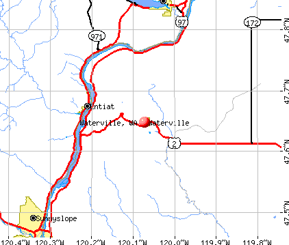
On a map linked here, Waterville, Washington is shown as being located east of Entiat, Washington. So it is evident that the tram being spoken of in the crack-in-the-ground entries is the same tram operated by the Columbia River Tramway Company, which was used to haul wheat down to the river landing and other goods back to the top of the plateau for use in Waterville.
At the bottom of PDF page 5 of 12, on the page linked here, is a map which indicates the apparent route of the old tram. It is directly across the Columbia River from Entiat, Washington. Information about this tram continues onto page 6. Since this tram is across the river from Entiat, Washington, this virtually confirms that this is the tram of which, across the canyon from it, was the hogback on which were those two cracks which opened in the ground during the 1872 earthquake, and spewed forth oil.
A page, linked here, gives more detailed information where the Waterville Wheat Tramway was located. It also notes that at the Rocky Reach Dam visitor center is a display on the history of this tram. Regarding the old tram, the page states: "All that remains is a concrete foundation with anchor bolts to mark the spot." A satellite photo, linked here, marks the "Top of Old Tram" and the "Hogback across from Tram" in relation to the town of Entiat, which is located on the west side of the Columbia River. Once again, the hogback across from the tram is where two cracks opened in the ground during the 1872 earthquake, and oil came out of the ground. Now back to other cracks or fissures which opened in the ground in 1872.
A USGS webpage, linked here, declares: "Most of the ground fissures occurred at the east end of Lake Chelan in the area of the Indian camp; in the Chelan Landing-Chelan Falls area; on a mountain about 19 kilimeters west of the Indian camp area; on the east side of the Columbia River (where three springs formed); and near the top of a ridge on a hogback on the east side of the Columbia River. These fissures formed in several localities of differing physiographic environments." The page also states: "Sulfurous water was emitted from the large fissures that formed in the Indian camp area. At Chelan Falls, 'a great hole opened in the earth' from which water spouted as much as 9 meters in the air. The geyser activity continued for several days, and, after diminishing, left permanent springs."
The USGS page, linked above, contains another piece of valuable information. It states: "Damaging intensities in Washington (MM intensity VI) extended on the west throughout the now densely populated Puget Sound basin and on the southeast to beyond the Hanford nuclear reactor site. The earthquake also was reported in Idaho, Montana, Oregon, and Canada. Many aftershocks were observed in the area over the next 2 years." Because of its great importance to our future, please note once again that "damaging intensities in Washington (MM intensity VI) extended on the west throughout the now densely populated Puget Sound basin and on the southeast to beyond the Hanford nuclear reactor site." As a cautionary note, it appears that Hanford Nuclear Reservation, with all of its highly radioactive units, could be seriously impacted if another one of these quakes occurred.
It is now time for some final considerations. The earthquake of 1872 opened cracks and fissures on both sides of the Cascade Mountains. On the east side of the Cascade Mountain, the area affected with ground cracking stretched from Chelan, in the north, to Entiat, in the south. On the west side of the Cascades, there was ground cracking on the south side of Seattle. A satellite photo, linked here, has Chelan and Entiat marked, on the east side of the Cascades, and Seattle marked on the west side. At this point, there is an important statement to make. Because of the cracking on both sides of the Cascade Mountains, and because the cracking took place in a relatively wide band on the east side of the mountains, it appears that the massive earthquake of 1872 was located on one of the much deeper fault networks which pass beneath the Cascades. These networks below the Cascades join fault systems on the west side to those on the east side of the mountain range.
The "interconnected [fault] system underlying the Cascades, from Puget Sound" to the east side of the Cascades, at least in the Hanford region, is noted in a webpage linked here. Another page which includes similar information about fault systems which pass under the Cascade Mountains is linked here.
In closing, there is one item on the Internet which could be of interest to this discussion. A page from the Montana Department of Transportation, linked here, in the left hand column (zoom in), speaks about "the Lewis and Clark Fault Zone, as series of faults that stretch between northwest Washington State and the Helena [Montana] area." If this fault zone stretches all the way to northwest Washington, then it would be reasonable to believe that it passes under the Cascade Mountains, somewhere in the region where the massive earthquake of 1872 occurred.
For further reading:
The Day the Earth Shook
http://www.inlander.com/spokane/the-day-the-earth-shook/Content?oid=2179535
Current Expectations for a Cascadia Mega-Quake
https://cascadian.neocities.org/cascadiaquake.htm



Wednesday, August 31, 2016
Bonneville Slide and the Cascadia Megaquake of 1700
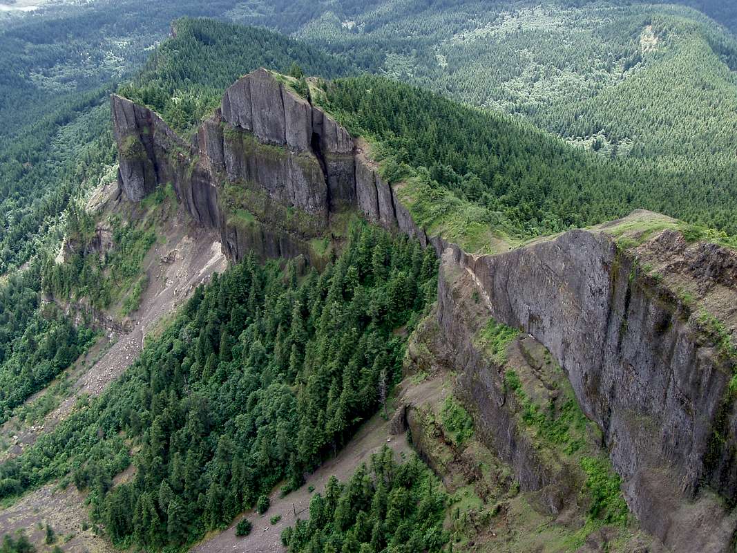
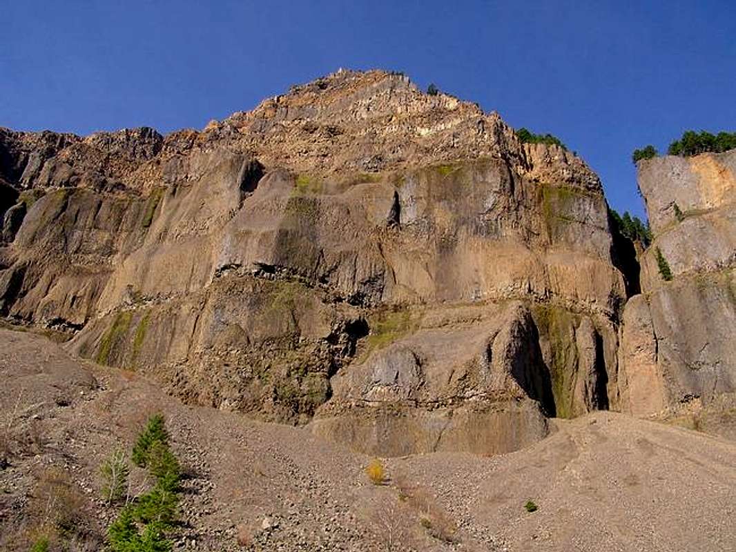
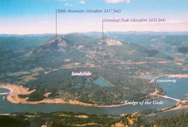
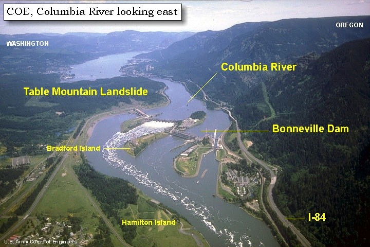
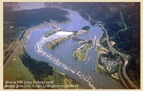
Some time in the past, something caused a large portion of a mountain, made of solid rock, to split off and tumble down, forming a large landslide which dammed the Columbia River for an extended period of time. This landslide occurred in the area where Cascade Locks, Oregon and Bonneville Dam are now located. Pictures which show the remaining face of this mountain, from which the massive amount of slide debris came, can be seen at the following links: (1) (2) (3) (4) (5). Views of the landslide can be seen in photos at the following links: (6) (7) (8) (9 - on PDF page 1 of 24).
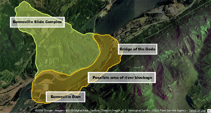
The fracture line on Table Mountain, which is linked to the Bonneville slide, generally is aligned from south-southwest to north-northeast, as can be seen in an aerial photo linked here. The debris from the mountain generally slid in a southeast direction, as can be seen in overlays on aerial photos, linked here and here. Photos of the face of Table Mountain and the Bonneville slide work together to tell an important story about events in the past which created the Bonneville Landslide Complex. These events should have extreme importance to us of this day, especially for those who live in the Cascadia earthquake zone.
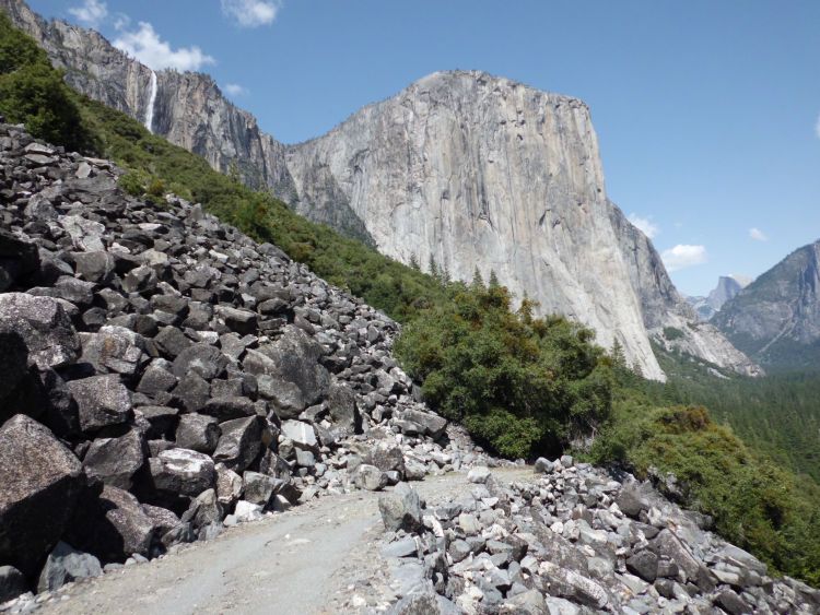
Closely examine photos which include the massive Bonneville Landslide (Table Mountain Landslide is part of the complex), which are located at the following links: (10) (11) (12) (13) (14). Take some time studying closely the photo in link number 14. There are a lot of important things which can be learned from all of these photos, especially when considering that the debris for this massive slide-complex came from tall mountains of solid rock.
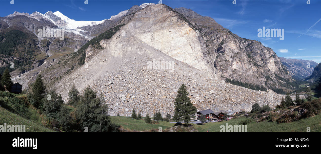
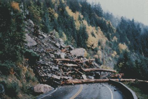
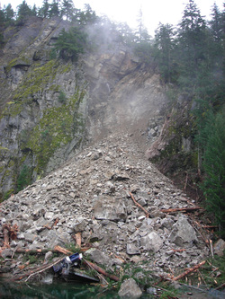
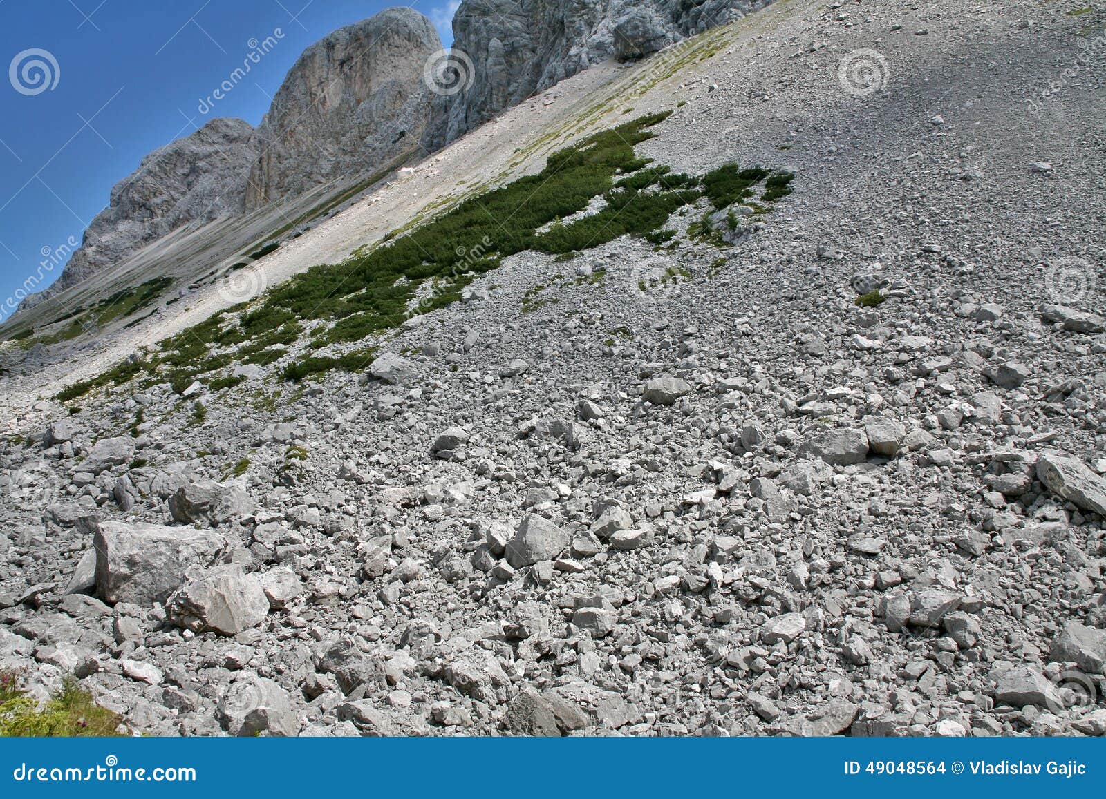
To learn the lessons which are told by the Bonneville Landslide Complex, we should first examine photos of normal rock slides from mountains to use as a comparison. Photos of normal rock slides from mountains are found at the following links: (15) (16) (17) (18) (19) (20) (21) (22). What can be learned from the preceding photos? Yes, normal rock slides from mountains generally slope downwards at a fairly steep angle.
Look once again at all the photos of the Bonneville slide. Look especially at the one in link number 14. In these photos, there are two important things to note. First, look at the distance this slide traveled, until it met the steep mountains on the Oregon side of the Columbia River. This was quite a distance, something which, in this instance, is unusual in this rock slide, especially one from mountains made of solid rock. But there is something even more important to note in these photos. Note the extreme shallow angle in the Bonneville slide, which can be seen the best in the photo in link number 14, above. What do these two factors, the distance the slide traveled and the shallow angle of the slide, have to tell us about what logically would have caused this massive slide?
The two factors, distance and angle, tell the writer that massive, long duration earthquakes were involved in the creation of the Bonneville Slide Complex. The initial slides from the mountains would have been steeply sloped. But intense shaking of a long duration would have caused the debris to keep moving outward and to spread out for a long distance. Intense shaking for a long duration would also leave a very shallow slope to the final debris field, as things shook greatly and sought a level state. It appears that this would be the most logical conclusion. Looking again at the general alignment of the shear cliffs on the rock mountains from which the slide debris came, which is shown in the aerial photo linked here, would tend to indicate that the massive earthquakes which caused the slides were centered generally to the west of these mountains, and possibly even to the west-northwest. It appears we are now looking at massive Cascadia megaquakes.
There have been a number of things written about the Bonneville slide. The dates that various people apply to this slide can vary widely. But, let us examine some of the evidence relating to this slide complex and come to our own logical conclusions. In a webpage, linked here, about half way down the page is a section titled 'Dating the Bonneville Landslide.' In about 1998, radiocarbon dating carried out for the USGS indicated that the Bonneville slide occurred somewhere "between 1500 and 1760." Counting of tree rings from one sample indicated that the tree from the slide "died in about 1699," which would place it very close to the quake of 1700. But there is more to this story.
The page linked in the paragraph above contains some other important information. It shows that in 2001, a scientist named Nathaniel D. Reynolds "used a technique called lichenometry to estimate the age of the Bonneville Landslide." The study of Reynolds indicates that the landslide likely occurred between 1670 and 1760. A publication by the Oregon Department of Geology and Mineral Industries, titled Oregon Geology, which is linked here, in the lower right corner of PDF page 2 or 24 (document page 130), declares the following: "The massive Bonneville slide into the Columbia Gorge has been recently dated at 300 years in the past. This places the slide at the same time as the last big subduction earthquake, suggesting that this seismic event may have triggered the landslide."
At this time, there is a lot to think about. It is said that the Cascadia megaquake of 1700 caused the orphan tsunami which hit Japan in January of that year. The size of the North American quake which produced this tsunami is said to have had a magnitude of 8.7 to 9.2 (link). In other words, this would have been the magnitude of the quake experienced in the coastal regions of what is now Oregon and Washington, in order to have produced the size of tsunami which hit Japan in 1700. But there is more to this story.
If the quake of 1700 was also instrumental in creating the gently sloping Bonneville slide, this appears to indicate an extremely intense earthquake of long duration which was centered far inland from the coastal regions of Oregon and Washington. It appears that the massive earthquake would have been centered relatively close to what is now the Interstate-5 freeway corridor. The magnitude of this intense quake of long duration is now up for anyone's guess. If centered far inland, to have shaken the coastal region severely enough to have produced the tsunami of 1700 would have required a quake with a magnitude far in excess of a 9.2, possibly even far in excess of a 9.2.
For further reading:
Current Expectations for a Cascadia Mega-Quake
https://cascadian.neocities.org/cascadiaquake.htm











Tuesday, August 30, 2016
Centered Inland, Rather Than Far Offshore ?
It is time to expand just a bit on the post which was made yesterday. Let us once again consider epicenters for the coming Cascadia megaquake. Most of the information about this coming quake predicts that the epicenters will be located at the offshore Cascadia Subduction Zone, roughly 70 miles off the coasts of Oregon and Washington. Nevertheless, it is time to ask a question. Is there any indication that the next full-potential Cascadia megaquake could be centered further toward shore or possibly even relatively far inland and much closer to large population centers? Furthermore, is there any chance that the devastating earthquake could be centered much closer to the Hanford Nuclear Reservation? In answer, it is time to consider the findings of scientists who do not appear to be part of the so-called "scientific consensus."
A webpage with information about seismic hazards associated with cities in Cascadia, linked here, on PDF page 3 of 63 states that "the upper limit of transient slip in the vicinity of Seattle, Washington and Vancouver, British Columbia comes close to the heavily urbanized regions." The information at the bottom of PDF page 3 of 63 and onto page 4 speaks of "observed interseismic deformation patterns, which is consistent with significant plate coupling extending closer to urbanized areas than has been previously thought." It declares that "the stress is likely accumulating much closer to the population centers of the Pacific Northwest than previously supposed." A diagram on PDF page 53 of 63 shows the zone of coupling extending inland as far as Portland, Oregon and Seattle, Washington, plus very near Vancouver, British Columbia.
An article, linked here, begins with the following words: "Major earthquakes occurring along the Cascadia subduction zone off the coast of Washington state could strike closer to the state's urban areas than some models have suggested, a new study notes." According to scientists at Central Washington University in Ellensburg, GPS data indicates that epicenters for quakes, which could exceed M9.0, could be "more than 60 kilometers (or roughly, more than 40 miles) inland. That means that epicenters for the next M9.0+ megaquake could potentially be very close to large population centers like Portland, Seattle and Vancouver BC. It also means that the potential exists for megaquake epicenters to be 110 miles or more closer to the Hanford Nuclear Reservation in central Washington state, than the public is commonly led to believe.
According to an NBC News article, linked here, there is a potential that Cascadia could rupture "within 68 miles of downtown Seattle, pouring seismic energy into a densely populated urban area, threatening to knock down buildings both large and small, and endangering the lives of millions." The article also indicates that the Cascadia slippage zone appears to be locked "right to the western edge of the Seattle metropolitan area." Furthermore, "Ground shaking could be up to five times stronger than anyone has planned for." At this point, there is something important to consider. In relatively recent times, the predictions of the so-called scientific consensus have often severely underestimated the actual, devastating earthquake events which ultimately occurred -- like at Sumatra in 2004 and Japan in 2011, just to name a couple.
So, why is the public steadily being told that epicenters for the next Cascadia megaquake will be about 70 miles offshore, when there is evidence which indicates that the epicenters could very likely be relatively close to major population centers? At this point, a question should be asked. Once again, is there a chance that the truth could be altered to protect the ambitions which certain entities have for the Hanford Nuclear Reservation? Could the truth about a more realistic location for epicenters of the next Cascadia megaquake have a negative effect on that which appears to be a large-scale tritium mining operation (commonly called the Pump and Treat Program) at this nuclear reservation? Is there a chance that the lives of the general public in the Cascadia region are being sacrificed for nuclear bomb ambitions? Or, is there another agenda in operation here? Possibly there is a lot more to the Cascadia story than the public generally realizes.
For further reading:
Current Expectations for a Cascadia Mega-Quake
https://cascadian.neocities.org/cascadiaquake.htm
Monday, August 29, 2016
Geologic Findings Favoring "The Highest Bidder" ?
The largest earthquake in Washington state, since white man first came to this region in the late 1700s, occurred on December 14, 1872. This major quake was first noted in this blog last Friday (8-26-16), in relation to the vulnerability of Grand Coulee Dam. There are now some other very important lessons for us of this day to learn. These lessons relate to this major earthquake and how information about it was handled in more recent times. Let us observe something very important. It appears that geologic information can readily be manipulated, especially in this case where the nuclear industry was involved.
A Seattle Times article, linked here, provides some background information relating to this quake. It notes that this "powerful quake...rattled seven states and provinces." According to Brian Sherrod of the USGS, this major earthquake "was felt from Montana and British Columbia down into Oregon and Northern California." Yes, you read that correctly, even into Northern California. So, it is obvious that this was a very large earthquake, especially since it was felt over such a wide area.
A map, linked here, which is from a page linked here, shows the area in the states of Washington, Oregon, Idaho and Montana, plus in Canadian provinces, in which this powerful quake was felt the most. To the writer, there is something interesting about this map. Note the general shape of the perimeter of the bluish-colored area. Then note that there is an isolated, bluish-colored area, which is located in the state of Montana. The shape of affected area on this map and the isolated area in Montana tell quite a story to the writer about a more realistic cause for the earthquake of 1872. This issue, about a more realistic cause, will be addressed in a later post. For now, let us get back to how the nuclear industry dealt with information about the 1872 quake, and important lessons we can learn from this.
In the 1970s, there was a push to build nuclear power plants in Washington state. One group had plans for three new reactors at the Hanford Nuclear Reservation. The other group wanted to build two nuclear power plants "on the Skagit River near Sedro-Woolley." But, there was a major problem. There was that massive earthquake of 1872, which included quite a number of aftershocks. As the article linked here states, "Building a nuclear power plant requires an analysis of the biggest earthquake in the past that might affect the structural capabilities of a plant in the future." In other words, the general public is supposed to be protected during a massive earthquake from a horrific nuclear accident also being included in the event. So, what did the players in the nuclear industry do about this serious problem, as they worked to protect their own interests?
A Seattle Times article, linked here, states that "legions of consultants employed by utilities with nuclear ambitions attempted to pin down the location of the quake." So, how did these "legions of consultants employed by utilities with nuclear ambitions" go about pinning down the location or epicenter of this large 1872 quake? Or, did the nuclear players do something completely different? Was the geologic information simply manipulated in the interests of the parties involved, so, in essence, they could possibly deceive an ignorant or gullible public and get their way?
An informative article found in The Cascadia Courier of Monday, April 18, 2011, which is linked here, is titled 'The Earthquake That Wouldn't Stay Put.' There is a very good reason why this title was given to the article. The various seismic consulting groups for the utility companies, in their so-called "findings," steadily "bounced" the the supposed "location" of the epicenter for the 1872 earthquake back and forth across the Cascade Mountains, even north and south, like a ricocheting ping-pong ball. It appears that each group was working hard to make "their team" the winner, no matter what. Yes, money talks, even in geology.
In The Cascadia Courier article linked in the preceding section, there is an account about a steamboat captain in Olympia, Washington, who was named Lawson. The earthquake felt in Olympia was initiated "with a light movement, [which was] gradually increasing for 18-20 seconds." This piece of information -- the nature of how things were initiated -- may be of value in a later examination of the nature of this quake, plus its actual cause. The account continues: "Then came the heavy shock, lasting four or five seconds; then it gradually decreased. In six minutes after the first shock there was another, followed by two others one minute apart." Once again, this information is valuable and will be examined closer in another post. For now, let us get back to the actions of the nuclear players in the 1970s.
It will be noted in The Cascadia Courier article, linked above, that consultants for one power company would present their "findings," which were naturally in favor of their client. Then the consultant for the opposing power company would counter with "findings" which were favorable to their client. It was almost like a case of "pay the attorney enough money and they will tell the court almost anything which they feel may work in their client's best interest, right or wrong." Read The Cascadia Courier article thoroughly and you may be educated on how "the game" is played, even in geology and even in very serious matters where the public safety is at stake.
Now, it is time to examine what is happening in our present day, in relation to the coming Cascadia mega-quake and its predicted epicenters by the so-called scientific consensus. The story which is given to the general public, via the media, is that the epicenters will be roughly 70 miles offshore at the so-called Cascadia Subduction Zone. But, it should be noted that there are a number of scientists whose investigations indicate that the epicenters will be far inland, much closer to large population centers and more than 110 miles closer to the Hanford Nuclear Reservation. Unfortunately, the scientists whose research indicates the epicenters will be relatively close to the Interstate-5 freeway corridor, and much closer to Hanford Nuclear Reservation, are not getting very much "press coverage." Instead, they seem to be getting largely ignored. Why is this?
Seeing how "the game" was played in the nuclear power industry, regarding the major quake in 1872, should help toward educating us. Yes, there are important lessons to consider about how the geologic information was handled or manipulated and why. At this point, there are some questions which possibly should be asked. Is there any chance that "the epicenters" noted in the so-called scientific consensus, regarding the coming Cascadia mega-quake, are "conveniently modified" to support or protect the U.S. Department of Energy's desired ambitions at the Hanford Nuclear Reservation? Is there a chance that someone does not want the public to understand the actual hazard which the Hanford Nuclear Reservation, in all its various units, presents in the event of a massive Cascadia mega-quake?
For further reading:
Current Expectations for a Cascadia Mega-Quake
https://cascadian.neocities.org/cascadiaquake.htm
Sunday, August 28, 2016
Considering Major Earthquakes and Volcanic Eruptions
Yesterday's post considered geologic events which are occurring in Italy, and how the basic principles involved in what is happening in that country may also apply in the Cascadia region. As we begin this discussion, let us consider that very explosive volcano near Rome, which is called Colli Albani. In recent times, this volcano has been slowly bulging, but scientists are currently assuring the world that it will not erupt violently for at least 1,000 years. But, let us consider how quickly things can change, when Nature finally begins to move. This information does have application in Cascadia and elsewhere.
Let us look at just one example of how quick and unexpectedly things can change, geologically. Let us look back to a geologic event which began on February 20, of 1943. On this day, a farmer in Mexico was working in his cornfields. To him, it was just another normal day. He was going about his business and getting the ground ready for planting his new crop. A page, linked here, gives the basic details about what happened next. When the farmer went to one of his fields, he noticed something a bit different. The linked page states: "...On top of a small hill in the field a huge crack, over six feet wide and 150 feet long, had appeared in the earth."
Yes, it appears this large crack was something new -- something which had formed since the last time the farmer had been to this field. Yes, it may have been very strange to have this feature in the ground, but, oh well, it was only about one foot deep. So, let's get back to getting ready for farming. As the farmer worked, suddenly, there was a rumbling sound and the ground started shaking. The ground where the crack was located began to swell and rise. There were strange hissing noises and ash was pouring out of a hole where the crack was. Smoke was coming out of the ground now, and the noises got louder and continuous. About this time, the farmer made his swift escape.
It is important to note that there had been warning signs prior to the rise of this rapidly growing volcano. The page linked above states that local residents of Paricutin "thought they had been hearing the sound of normal thunder in the weeks that preceded the eruption, though they were puzzled by the lack of storm clouds in the sky." So, what what producing all these rumbling or booming sounds? It was caused by "the movement of magma deep inside the earth." The local residents also felt ground tremors, as Nature was preparing to build the volcano of Paricutin.
Paracutin is classed as a scoria cone. Scoria cones are also called "cinder cones."(1) This type of volcano can suddenly "appear out of nowhere" and quickly build into a rather large, steep-sided mountain. At this point, it should be noted that there is a large cinder cone right in the middle of Portland, Oregon. This volcano is called Mount Tabor.(2) Rocky Butte, Powell Butte, and Kelly Butte are also volcanic cinder cones. Let it be further noted that many residences are built on these volcanoes.
Portland is actually built in the Boring Lava Field.(3) There are "at least 32 cinder cones and small shield volcanoes lying within a radius of 13 miles of Kelly Butte," on the east side of Portland. But, as usual, there is more to this story. In the Portland area there are at least 95 lava vents. These vents are even included in the West Hills of Portland. The 95 vents are noted on a map, which is linked here. The bottom line is, there are many residences scattered around and over virtually all of these lava vents.
In former times, scientists did not believe that large earthquakes could trigger volcanic activity. But now, it appears that some of their thinking is beginning to change and some now tend to believe that major earthquakes may possibly trigger volcanoes. One example of this change in thinking is a page containing information about two volcanoes which erupted after the M9.3 Sumatra earthquake of 2004. That page is linked here.
A National Geographic page, which includes information relating to earthquake-induced volcanic eruptions, is linked here. A webpage, linked here, speaks of the Cascade Graben in the Cascade Mountains in Oregon, in which are located a number of volcanoes. This graben is under compression at this time. But, the information notes that "during a large Cascadia subduction earthquake, the normal stress on the graben would reverse..." That means that the stress would then become extensional. This means that there could be a stretching or weakening of the continental crust in this area.
When the continental crust around volcanoes in the Cascade Mountains is stretched or weakened, the page states that "this would enhance the possibility of an eruption where magma accumulation is critically stressing the crust..." Let us consider this concept further. Is there a chance that during the next Cascadia mega-quake, the earth's crust in the Portland area and surrounding region could once again be weakened? Is there a chance that cracks could form in the ground in this region? And finally, is there a remote chance that this region could experience volcanic activity, once again, with lava pouring out of the ground and consuming whatever it comes in contact with?
For further reading:
Current Expectations for a Cascadia Mega-Quake
https://cascadian.neocities.org/cascadiaquake.htm

Saturday, August 27, 2016
Seismologists, Cascadia and Recent World Earthquakes
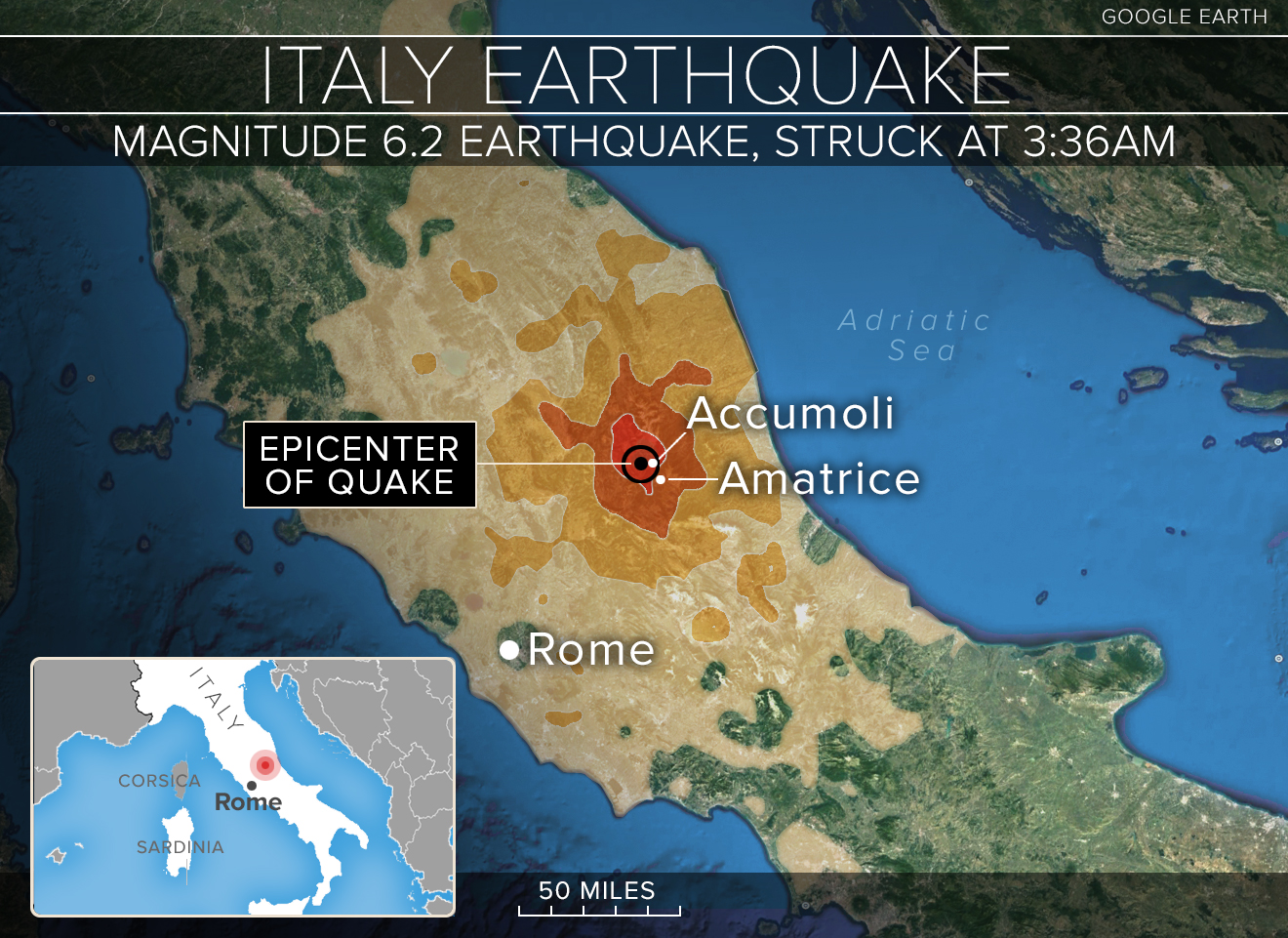
Today, let us deviate just a bit from subject matter which is purely 'Cascadian' in nature. An August 26, 2016 article in The Lewiston Tribune, linked here, is titled 'Recent earthquakes have Northwest seismologists talking.' The article starts with these words: "The earthquakes in Italy and Myanmar are a grim reminder of the seismic dangers Puget Sounders face."
The linked article notes that the recent earthquake in Italy "is comparable to a rupture of a shallow fault, like the Seattle Fault, which cuts across Bremerton through South Seattle to the Cascade foothills." The article then declares that there are differences between what is happening, geologically, in Italy and what is happening in the Cascadia region. It states that in Italy, "the tectonic plates are spreading away from one another," while in the Cascadia region, "we're basically being squeezed from Oregon to Canada, which creates thrust faults."
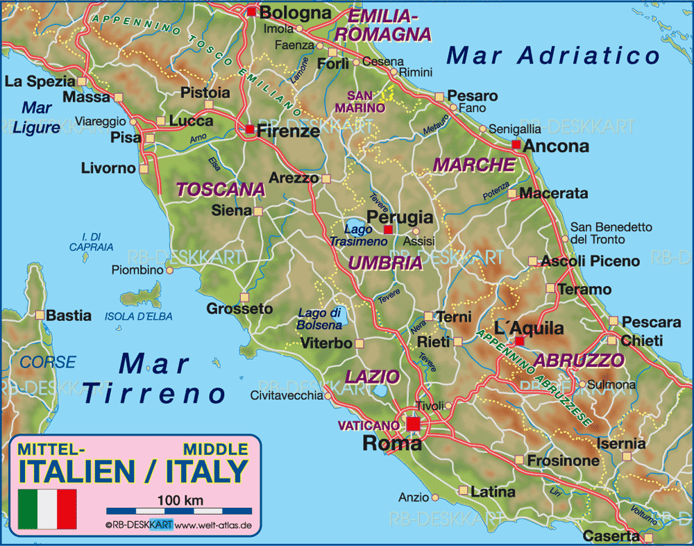
Let us look, for a moment, at what is actually happening, geologically, in Italy in the region in which the recent earthquake occurred. There exists a deep fault in central Italy which extends from the city of Anzio (which is south of Rome) in a northeasterly direction all the way to the city of Ancona, on the east coast of Italy. These two cities (Anzio, south of Rome, on the coast, and Ancona, in a northerly direction on the opposite coast) are shown on the map linked here. This deep fault between these two coastal cities is along what is commonly called the Ancona-Anzio Line. A book titled 'Earthquakes: Observation, Theory and Interpretation' [Kanamori and Boschi, Paperback Edition, 1986, page 525] indicates that in the region of this line, there is a release of seismic energy which is greater than that in all the surrounding parts of Italy. It also indicates that subcrustal quakes occur along this line.
It should be noted that the recent Italian earthquake was located "in the region" of the Ancona-Anzio Line, as can be seen on the maps linked here and here, and in a map within the article linked here.
The 'Earthquakes...' book referenced further above [on pages 525 and 527] indicates that the cause of earthquakes in the region of the Ancona-Anzio Line is because of the difference in behavior of the tectonic plates on each side of the line. A map on page 524 of the referenced book indicates that the Ancona-Anzio Line is the point at which the southern portion of Italy is underthrusting the northern portion. Once again, this compression and thrusting is similar to what is occurring along the coastal areas of Cascadia. A USGS page linked here states: "Northward motion of Oregon block squeezes western Washington against Canadian Coast Mountains restraining bend, causing N-S compression, uplift, thrust faulting, and earthquakes." But, there is more for us to consider in the story about what is happening with Italy.
The 'Earthquakes...' book referred further above, on the map found on page 524, shows that things are a bit more complicated in Italy along this Ancona-Anzio Line. It indicates that the southern portion of Italy, below the cross-country fault line, is slowly rotating counterclockwise, in relation to the northern portion of Italy. This would indicate that any spreading of tectonic plates from one another, as mentioned in The Lewiston Tribune article, would tend to exist on the western side of Italy, near Rome. Could this spreading or weakening of the landmass in the region near Rome be part of the reason that Colli Albani appears to be awakening and possibly preparing for another one of its very explosive, eruptive cycles? Information about Colli Albani and its eruptive cycles can be found in the following four links: (1) (2) (3) (4)
On the map linked here, note the locations of Roma (Rome) and Latina in relation to the volcano at Albano (Vulcano Albano). Note also the location of Anzio on the Google map, linked here. It can clearly be seen that the volcano at Albano (marked with the red marker in the Google map) is located on the spreading or weakening end of the Ancona-Anzio fault line. With recent movement taking place along the Ancona-Anzio Line in the central part of Italy, just how long could it truly be before the landmass at Albano is weakened enough to let the magma explosively break through, once again? Will it happen before or after Cascadia cuts loose with its devastating mega-quake?
For further reading:
Current Expectations for a Cascadia Mega-Quake
https://cascadian.neocities.org/cascadiaquake.htm


Friday, August 26, 2016
Grand Coulee Dam and Washington's Largest Earthquake
On December 14, 1872, one of the largest earthquakes ever recorded in the state of Washington occurred. Since there were no seismic recording instruments in place in those days, there is no accurate record of the actual size of this large quake. Estimates for this quake currently run as high as M7.5.
Even though this earthquake was centered east of the Cascade Mountains, damage from it was noted even west of the Cascades. Regarding this quake, a webpage linked here states that "chimneys cracked in Olympia, trees toppled in Puyallup and fissures split the ground south of Seattle." The page notes further that "windows also shattered as far away as Victoria, B.C., and people were knocked off their feet at Snoqualmie Pass."
Looking toward the north and east, a page linked here states: "People in towns as far east as Henry House, Alberta [about 340 miles away, and on the other side of the Rocky Mountains], and Virginia City, Mont. [about 450 miles away, with the Bitterroot Range between], felt the quake as a succession of mild shocks." The page notes further that at Chilliwack in British Columbia, Canada, upstream on the Fraser River [about 130 miles away, with the Cascade Mountains between], "the houses commenced to oscillate; the earth rose like waves of the sea; the rivers splashed their banks."
From the things stated above, it is very obvious that this 1872 quake, which was centered somewhere in the eastern part of Washington state, was felt over quite a large area. But, there is yet more to this story, as we consider just some of those things which occurred in the region where Grand Coulee Dam is now located.
East of the Cascades, the shaking was so severe that a giant landslide temporarily dammed the Columbia River near what is now Entiat, Washington. Looking further to the east, a webpage linked here notes that big things were happening around the Whitestone area. The original site of Whitestone is "just downstream from the mouth of the Spokane River." As a note, the original site of Whitestone is now covered over by the waters in the reservoir behind Grand Coulee Dam. The dam itself is located not very far downstream from the original site of Whitestone. So, what was happening at Whitestone during the earthquake of 1872?
An eyewitness (who is spoken about in the previous link) stated that there were 142 distinct shocks over a period of 42 days. Near Whitestone, a large crack formed in the ground. Near this area, one bank of the Columbia River "caved off and settled down for two or three hundred yards." The mountains and cliffs in the area were shaken so severely that large masses of rock were "constantly falling, tumbling and sliding down" for quite a period of time afterward. It is obvious that this was an incredibly large quake in 1872, but there is more to this story.
In 1933, just 61 years after the major earthquake had greatly affected the Whitestone area, the construction of Grand Coulee Dam began. The original construction phase for the dam lasted for a period of about 9 years, until 1942. Grand Coulee Dam is the largest facility in the United States for producing electrical power. Because of all its uses, this facility is very important to the United States and its economy.
Now, it is time to consider what was dealt with during the construction of Grand Coulee Dam. During bedrock preparations for the dam, a Washington State University Libraries webpage (linked here) notes that a deep hole had to be excavated into the bedrock so they could attempt to seal up the deep fissures beneath the dam. The page clearly notes that these deep fissures are part of a fault zone or an ancient fault line. So, it is clear that those people who were heading the dam building project knew that it was being built in a fault zone. In other words, it is clear that the dam was knowingly built in a geologic zone of weakness.
To some, it appears that this fault zone at Grand Coulee Dam may be associated with the Lewis & Clark Fault Zone. But to the writer, it appears that this fault zone may be associated with a giant cross-nation rift which extends diagonally across North America, from Georgia (in the southeast) to Washington state (in the northwest). For those desiring additional information about this giant rift, more is written about it in the writer's webpage called 'Current Expectations for a Cascadia Mega-Quake.' The rift information is found in the right-hand margin, starting at the level linked here.
So, what could be the consequences of building Grand Coulee Dam directly in a major fault zone, where things clearly moved on a rather large scale in 1872? For starters, it appears that during a massive earthquake in the region, Grand Coulee Dam could potentially fail, possibly even catastrophically, producing devastating effects downstream. If Grand Coulee Dam were to fail, the wall of water and debris could blast out the dams below it on the Columbia River, plus cause an immense amount of other damage downstream. Information regarding this matter is found on PDF page 2 of 3, of the page linked here. And, in just a bit, we will again look at the information from the linked page, but in just a little more detail.
Now, there are some who may state that there is "no active fault, known or suspected at Grand Coulee Dam." Well, if it moved in 1872, there is reason to suspect that there are faults in that area which have the potential for moving again, possibly even in the not too distant future. Furthermore, when the "pros" say that there is no active fault, known or suspected, we really should look at the history of the "pros," where they have been utterly wrong and thoroughly blindsided in earthquake events in more recent times and people have needlessly died because of it, because things were different than the "pros" computer models showed. The history of some of this type of thing is presented in various other posts in this blog.
Looking at things further, regarding the predicament of Grand Coulee Dam, there are some who are proposing a "postulated seismic failure of Grand Coulee Dam," wherein the dam would not have a catastrophic failure, but only a part of the dam structure would fail and the remaining portion of the dam would "act as a restriction or weir and minimize the hydraulic failure." Well, again, we must consider how the "pros" have been wrong at what has happened in earthquake events in recent times.
The writer, for one, has no plans of gullibly hoping for the best in this highly questionable situation and then getting utterly devastated, by thinking that there would be just a postulated seismic failure of the dam and then finding out that things are actually much different in real life than the potentially flawed computer models showed. Furthermore, there is no genuine guarantee that an earthquake even larger than the 1872 quake could not happen in the region near the dam.
Now, when it comes to Grand Coulee Dam and its potential for experiencing a catastrophic failure, rather than simply a "postulated seismic failure," there is something to look at more closely. In 2013, as found in that page linked here, there was testimony given to the Nuclear Regulatory Commission (NRC) Petition Review Board which related to the nuclear power plant on the old Hanford Nuclear Reservation site. But, on PDF page 2 of 3 in this testimony, there is some information presented which relates directly to Grand Coulee Dam.
The page of testimony clearly states: "According to the NRC's own studies, a complete dam breach at Grand Coulee, whether through earthquake or terrorist act, would send a wall of water blasting out the seven dams below it on the Columbia River..." Well, as each dam on the Columbia River below Grand Coulee was blasted out, it appears that it would add to the size of the flash flood created by the initial Grand Coulee failure. Now, at this point, there is even more to consider. Let us seriously look at what the Nuclear Regulatory Commission (NRC) was concerned about in its own studies.
The NRC was concerned about the potential for a catastrophic flood being created on the Columbia River that could possibly even affect things at the Hanford Nuclear Reservation. The NRC was concerned that a complete dam breach at Grand Coulee Dam could then allow for flash flood waters to possibly even blast out the dams below it on the Columbia River. Now, it appears that the NRC felt that such a scenario was possible, so possibly a scenario like this is something which we should take seriously and not just hope for the best and plan for only some sort of a "postulated seismic failure" to occur at Grand Coulee Dam, should a massive earthquake seriously affect the region where the dam is located.
When it comes to Grand Coulee Dam, there is another thing to consider. The "pros" are not concerned about a Cascadia earthquake affecting Grand Coulee Dam, because they are basing things off of a belief that the next Cascadia earthquake will be located far offshore in the Pacific Ocean. Well, can they guarantee that they are absolutely accurate on this one?
For those with an interest, there is information contained in other posts on this blog which give reason to suspect that the next massive Cascadia earthquake could be centered somewhere much nearer to the Cascade Mountains, rather than far offshore in the Pacific Ocean. This could possibly radically change the picture for Grand Coulee Dam.
For additional information relating to the giant cross-nation rift and Grand Coulee Dam, plus information relating to Hanford Nuclear Reservation and a Cascadia mega-quake, just scan down through the information in the whole right-hand margin of the writer's Cascadia report, which is linked here. Then, for even further information which is specifically directed at the situation surrounding Grand Coulee Dam, check out a page linked here, which page is titled The Apparent Predicament of Grand Coulee Dam. And now, let us look at just some of the highlights which are found within the linked Grand Coulee Dam page.
When they were planning on building Grand Coulee Dam, some form of geologic testing was done. Those doing the testing declared that there was solid granite rock beneath the dam site, and that is what many people and agencies still "parrot" today about that dam site. But, once the excavation of the site was well under way, after the July 1933 start date, it was found that the bedrock was quite different beneath this site. Yes, possibly there was someone who wanted the dam project to be done so badly, that they may have done a little bit of "fudging" on the initial geologic testing reports.
Once the actual excavation for the dam site was well under way, it was found that there was a series of north-trending, geologic dikes. But, that is only part of the story. It was also found that there were "several shear zones and faults" in the rock beneath the dam site. So, let us look a bit closer at what actually was found to exist beneath Grand Coulee Dam.
A 1938 report declared that there were found "three major systems of joints [which] cut the foundation granites," with "closely fractured rock resembling weakly defined shear zones," which exists beneath the dam. A couple of these major systems of joints or faults even crossed each other at virtually right-angles beneath the dam site. Well, this tends to indicate that there may be a somewhat weak geologic structure beneath the dam. So, what did they do to hide or cover up this problem?
Well, they did a lot of "overexcavation, scaling, and bolting" in this fractured bedrock. Then, the chief design engineer for the dam project spoke of "the treatment of extensive shear zones at Grand Coulee Dam by unprecedented grouting..." That's right folks, just squirt a whole bunch of grout into those messed up shear zones and expect Nature to forever cooperate with you and not go ahead and get rowdy and just shake things loose!
Now, let's summarize what the Grand Coulee page, linked further above, found that there is beneath Grand Coulee Dam. It states that there was found "faults, joints, intrusions and intrusive contacts, plus extensive shear zones in the bedrock beneath Grand Coulee Dam." Then the linked page contains the following information from a source: "For concrete dams founded on rock, sliding on discontinuities (e.g. joints, fracture zones, intrusion contacts, faults, shears, bedding, foliation, etc...) within the foundation rock mass is the leading cause of historical failures."
Well, so much for Grand Coulee Dam! And then, there is another problem to consider, especially with all of those faults, joints, and extensive shear zones in the bedrock beneath the dam. The linked page speaks of paths of seepage developing, which can work to erode or weaken the bedrock even further, which is beneath and is supposed to be supporting the dam. And then, in the midst of all this, there is that nasty "lift seam" which is located below the dam site, which "lift seam" is explained in the linked page.
At this point, there is one very important thing to note. The linked page states that a "lift seam" can present a hazard for the dam structure, plus can "destabilize the dam's foundation," especially in the event of an earthquake. Now, in the case of Grand Coulee Dam, it appears that this "lift seam" is a rather weak or unstable, 400-foot-wide zone which is filled with clay and disintegrated granites. So, what did they do about this rather large and hazardous "lift seam" which resides beneath Grand Coulee Dam?
Well, they cleaned out as much of the loose junk as they could. Then, they jammed the seam as full of grout as they could, and then they simply hoped for the best. Possibly they also hoped that they were all dead and gone before anything serious became of this situation and people realized what they had really done, when they built the foundation for Grand Coulee Dam. Yes, it appears that in this rather unstable "lift seam" beneath the dam is where they did some of that "unprecedented grouting." And, there is a lot more to the story about Grand Coulee Dam, plus what is beneath it, some of which is revealed in that page which is again linked here.
There is another thing which should be included in this post. There is actually more to the "lift seam" problem at the Grand Coulee Dam site than just the dam itself. In the page linked above is also found the following quote from a source: "When the excavation of the pumping plant was being performed, a so-called 'lift-seam' in the rock was noted. This extensive sloping joint structure in the bedrock in the back wall of the pumping plant was viewed as a potential hazard in the event of an earthquake."
So, it appears that there is not only a huge and potentially dangerous "lift seam" under the dam itself, which could potentially create a catastrophic problem in the event of a huge earthquake, but there is also a potentially hazardous "lift seam" in the back wall area of the large pumping plant which is located at the west end of the dam. There is reason to suspect that both of these "lift seams" could create some serious or very dangerous problems, in the event of a huge earthquake which strongly affects this area.
For further reading:
Current Expectations for a Cascadia Mega-Quake
https://cascadian.neocities.org/cascadiaquake.htm
Thursday, August 25, 2016
On the Columbia River, Near Portland
The hazard presented by the Hanford Nuclear Reservation, in the event of a Cascadia mega-quake, was lightly touched upon in yesterday's post. But, there is a nuclear hazard which is much closer to a major population center and the very important Interstate-5 freeway corridor. Furthermore, this nuclear hazard is situated on the banks of the Columbia River, where it, in the event of a massive mega-quake, presents the potential for a serious nuclear disaster in a populated region. This nuclear hazard resides at the site of the old Trojan Nuclear Plant, near Rainier Oregon.
But, you say, the plant was decommissioned and demolished long ago and its nuclear reactor vessel was hauled to the Hanford Nuclear Reservation. So, what is the problem? The potential problem is the 34 "spent-fuel" casks which reside outdoors on a concrete pad, beside the Columbia River. Yes, there is at least a chain-link fence around them and someone guarding them. The KOIN article linked below states: "But what the security guards can't prevent, an earthquake, is the biggest threat to Trojan." The article then brings up an important point. It states: "The silos [casks] sit on an earthquake fault." Yes, that is right folks -- "on an earthquake fault."
Can radioactive waste at Trojan withstand a major quake?
http://koin.com/2016/05/04/can-radioactive-waste-at-trojan-withstand-a-major-quake/
The article linked above contains even more information which is worthy of further examination. It states that the 34 casks "hold more than 379 tons of highly radioactive nuclear waste" which is in the form of "790 spent uranium fuel rods." But, what is said about this "highly radioactive nuclear waste" and its storage containers, in the event of an earthquake? Let us consider what is being said by a spokesman from Portland General Electric, named Steve Corson.
Regarding a major earthquake, Corson declares: "We would not expect to see any damage to these storage containers as a result of something like that." But, let us look at things closer. A Cascadia mega-quake is not in the class of just a major earthquake. A major earthquake is generally one with a magnitude of 7.0 to 7.9. In Cascadia, we are talking about an earthquake with a magnitude of 9.0+ and potentially lasting for a number of minutes. Then, regarding movement of the storage casks during an earthquake, Corson declares: "Even movement shouldn't be a problem, even if you knocked one over, that should not be a problem." But, there is more to consider about what will likely be happening during a genuine Cascadia mega-quake.
Once again, let us note that the 34 storage casks at the Trojan site sit on an earthquake fault. This fault appears to generally reside above the ancient, deeply buried concealed rift. At this point, it should be noted that a number of scientists are stating that the epicenters for the next Cascadia mega-quake could be located inland, much closer to population centers. Therefore, during a massive Cascadia event, the intensity and duration of shaking could be much greater than the rather casual picture which PGE is presenting to the public. In a full-blown Cascadia mega-quake, it may be much more than just one cask being knocked over. With the potential for large-scale, undulating surface waves (with the surface of the ground moving like ocean swells, like that illustrated in the links below) occurring over a period of a number of minutes, it is very possible that a number of these casks will be knocked over. But there is more to this story.
Surface waves - The ground surface rolls with a wavelike motion
https://classconnection.s3.amazonaws.com/754/flashcards/1160754/png/surface_waves1328630254568.png
D. Surface wave
http://www.webpages.uidaho.edu/~simkat/cors220_files/Rayleighwave.jpg
Surface waves
http://image.slidesharecdn.com/seismicwavesfinal2-150226104326-conversion-gate02/95/seismic-waves-5-638.jpg?cb=1424952325
Each of the 34 casks at Trojan is said to weigh about 150 tons. In a massive mega-quake with large, undulating surface waves which last for a number of minutes, these 150 ton items could potentially be smashing into one another -- 150 ton rigid items smashing into 150 ton rigid items, like giant wrecking balls -- repeatedly. Considering this scenario further, during a massive mega-quake, these rigid containers could be beating each other to pieces, exposing their highly radioactive contents to the open air and the surrounding environment. And, if enough of this nuclear fuel ends up being stacked together, what could happen? Is there a potential for a criticality accident to occur? Could there be an open-air, uncontrolled nuclear chain reaction -- in Portland's "back yard?"
Jeff Gianola and the Koin News Staff must be commended on their effort in the article which is linked above. They make it clear that PGE "can only speculate about earthquake damage," and PGE's speculation is that "the radioactive waste stored at Trojan will survive a natural disaster." It is time to consider the wording used, and yes, PGE has their image and liability to protect. But, there is once again more to consider here. Yes, this radioactive waste at Trojan may survive "a natural disaster." But, can it realistically survive a full-blown mega-quake event intact and fully contained, if Cascadia should cut loose with its full potential? Can it survive such an event without radiation being spread abroad in the surrounding environment, via wind and river. These are just a couple of the questions which truly must be considered -- before the quake occurs.
For further reading:
Current Expectations for a Cascadia Mega-Quake
https://cascadian.neocities.org/cascadiaquake.htm


Wednesday, August 24, 2016
The Eastern Connection and Hanford
An article (linked here: http://www.hcn.org/issues/43.17/washingtons-hanford-reservation-and-nuclear-plant-may-lie-on-faults) notes that as far back as at least 2011, Brian Sherrod of the USGS was investigating features in the Yakima Fold and Thrust Belt. He found evidence which indicates that the seismic hazards which lie west of the Cascades are very likely connected to seismic features to the east of the Cascades via "an interconnected system" of faults which exist beneath and pass under the Cascade Mountains.
This interconnected fault system, to the east of the Cascades, includes features like Umtanum Ridge and Rattlesnake Mountain, the latter being situated on the southwestern side of the Hanford Nuclear Reservation. It appears that this fault system which passes under the Cascades is related to the Olympic Wallowa Lineament (OWL). The OWL it that physiographic feature which spans from the northern end of the Olympic Peninsula, in northwestern Washington, to the Wallowa Mountains in eastern Oregon.
This fault system which passes beneath the Cascades tends to indicate that during the next full-potential Cascadia mega-quake event, Hanford Nuclear Reservation and the Vitrification Plant could take a severe hit. The earthquake which Hanford experiences could be far in excess of current seismic estimates for that facility. Could this translate to a nuclear catastrophe during the next Cascadia mega-quake? Could this mean a spread of radiation across the region via air currents and the Columbia River?
Links to Further Reading:
Current Expectations for a Cascadia Mega-Quake
https://cascadian.neocities.org/cascadiaquake.htm
Lessons from Japan: Is Hanford Ready to Withstand a Big Earthquake? (2011)
http://www.seattlemag.com/article/lessons-japan-hanford-ready-withstand-big-earthquake
Washington's Columbia Generating Station Is a Seismic Timebomb (2014)
http://www.earthisland.org/journal/index.php/elist/eListRead/washingtons_columbia_generating_station_is_a_seismic_timebomb/
Evaluation of Energy Northwest Response...to...NRC Request (2013)
http://www.psr.org/chapters/oregon/assets/pdfs/cgs-seismic-study/tolan-eq-report-2-10-31-13.pdf
Hanford nuke plant's earthquake risk underestimated, group says (2013)
http://www.seattletimes.com/seattle-news/hanford-nuke-plantrsquos-earthquake-risk-underestimated-group-says/
New fault lines discovered in western Washington (2012)
http://www.homelandsecuritynewswire.com/dr20120111-new-fault-lines-discovered-in-western-washington
Research shakes up seismic knowledge near Northwest nuclear plant (2014)
https://www.radcast.org/category/earthquakes-and-cgs/
State geologists want better quake preparedness here (2011)
http://tdn.com/mobile/article_2a4bacfc-4f23-11e0-aec2-001cc4c002e0.html
Earthquake fault much larger, more dangerous than thought (2009)
http://www.mcclatchydc.com/news/politics-government/congress/article24539437.html
Hanford Nuclear Waste Site and The Columbia Generating Station in Richland, WA (2014)
https://www.radcast.org/hanfordcgs/
Part 1: Seismic Risks to CGS - What the NRC Doesn't Want You to Know (2014)
https://www.radcast.org/seismic-risks-to-cgs-what-the-nrc-doesnt-want-you-to-know/
Part 2: Seismic Risks to CGS - What the NRC Doesn't Want You to Know (2014)
https://www.radcast.org/part-2seismic-risks-to-cgs-what-the-nrc-doesnt-want-you-to-know/
Part 3: Seismic Risks to CGS - What the NRC Doesn't Want You to Know (2014)
https://www.radcast.org/part3/
Part 4: Seismic Risks to CGS - What the NRC Doesn't Want You to Know (2014)
https://www.radcast.org/part-4seismic-risks-to-cgs-what-the-nrc-doesnt-want-you-to-know/
Connecting the Yakima fold and thrust belt to active faults in the Puget Lowland, Washington (Abstract - 2010)
https://pubs.er.usgs.gov/publication/70036529
Connecting the Yakima fold and thrust belt to active faults in the Puget Lowland, Washington (Full text - 2010)
http://earthweb.ess.washington.edu/bsherrod/brian/blakely_2011_JGR.pdf
Connecting the Yakima fold and thrust belt to active faults in the Puget Lowland, Washington (Abstract and Full text - 2011)
http://onlinelibrary.wiley.com/doi/10.1029/2010JB008091/full
Connecting Crustal Faults and Tectonics from Puget Sound across the Cascade Range to the Yakima Fold and Thrust Belt, Washington: Evidence from New High-Resolution Aeromagnetic Data (Abstract - 2009)
http://adsabs.harvard.edu/abs/2009AGUSMGP23A..02B
Connecting the Yakima Fold and Thrust Belt to Active Faults in the Puget Sound, Washington: Evidence from High-Resolution Aeromagnetic and Regional Gravity Anomalies (2009)
https://gsa.confex.com/gsa/2009AM/finalprogram/abstract_162600.htm
Tuesday, August 23, 2016
Introducing this Blog
A considerable amount of research, writing and updating has gone into the Cascadia Mega-Quake webpage, since it was first loaded to the Internet in the early part of 2014. The Cascadia page works to present a more realistic picture of what to expect, should a Cascadia mega-quake break loose with its full potential. That page also shows ways to potentially recognize when a world-class quake is about to happen. Furthermore, the page gives pointers on how to potentially prepare for such a devastating event.
In this Cascadian Alert blog, specific things relating to the Cascadia region of North America will be presented and discussed. Geologic issues from around the world may also be examined at times, as we search for lessons which can apply to Cascadia.
Your host, David Sakrisson, welcomes comments from readers. Readers may also contact David about subjects which may be of interest to discuss. One thing is to be noted -- the Cascadia Mega-Quake webpage and this blog are intended for the average person who may have some interest in geology and just simply wants a better understanding of what is going on. Your host will do his best to keep things at this level, so all can understand and enjoy the discussion.
With this short introduction, this blog is now launched.