Saturday, September 30, 2017

The Grand Collision -- Part 1 -- Initiation of Movement

This is the beginning of a multi-post series which should help to explain a very important, grand collision which it appears the North American continent experienced in earlier times. This collision appears to have occurred during the westward movement of the continent across the face of the earth. Understanding this specific grand collision should help to better understand what is being dealt with today, geologically, in western North America, plus how it relates to the fast approaching Cascadia earthquake event.

There have been theories over time about how the continents move and have moved across the face of the earth. One early theory was called "continental drift" (1) (2) (3). Later, the theory of continental drift was largely replaced by the theory of plate tectonics (4). But, in all of this, a question should possibly be asked. What initiated all this movement of the continents?

A page, linked here, contains the following statement: "All the rocky planets in our solar system -- Mercury, Venus, Earth and Mars -- have the same internal structure. But only Earth's crust shows signs of plate motion." According to researchers noted in the article, "something [had] to destabilise the crust." Something had to fracture the crust into pieces which could then allow for setting the plates into motion. The researchers believe that it was a massive asteroid impact which broke up the crust of the earth and initiated the movement of the continents.

Further pages, which include information about an impactor or impactors from space potentially moving continents, are accessed via the following links: (5) (6) (7) (8) (9) (10) (11) (12) (13)

Now, looking to our day, a page, linked here, states that "astronomers are discovering more and more large asteroids that could one day collide with Earth. The planet, says Dr. Eugene M. Shoemaker of the United States Geological Survey, 'resides in an asteroid swarm.'" The page states further: "Experts also say that further asteroid or comet collisions with Earth must be expected because the number of asteroids discovered in orbits that cross or come near that of Earth is increasing rapidly." So, what could these collisions or impacts have upon the face of the earth?

For a moment, let us consider impactors from space causing movement of physical features on the surface of the earth. A prophecy in a historic document contains the following words: "And I beheld when he had opened the sixth seal, and, lo, there was a great earthquake; and the sun became black as sackcloth of hair, and the moon became as blood; and the stars of heaven fell unto the earth, even as a fig tree casteth her untimely figs, when she is shaken of a mighty wind. And the heaven departed as a scroll when it is rolled together; and every mountain and island were moved out of their places."(link)

After considering all the information presented or linked above, it is possibly reasonable to believe that impactors from space could have initiated movement of the landmasses upon the face of this earth. It is also reasonable to believe that large impactors from space, with their associated force, could cause sudden and relatively fast movement of the affected landmasses. With these considerations in mind, let us now prepare move onward.

The next post in this series will examine a specific portion of the "grand collision" which it appears the North American continent experienced in earlier times, after it was sent on is westward voyage. This grand collision appears to have set the stage for a massive Cascadia earthquake event --- one which we may see in our lifetimes. 


NOTE: As important information comes to the attention of the blogger, other posts may appear between the various parts of 'The Grand Collision' series. At the time of this writing, six parts are planned for the series. At a later date, that number could change as a result of additional information.


For further reading:

Current Expectations for a Cascadia Mega-Quake
https://cascadian.neocities.org/cascadiaquake.htm


Wednesday, September 27, 2017

We have Many of These Types of Buildings in Our Cities

There is a page from the Los Angeles Times, linked here, which I believe everyone should look at closely and understand the implications of it --- especially when it comes to the Cascadia region of North America and the coming mega-quake. The title of the Los Angeles Times article is: 'It was a Mexico City office building. Now, after the earthquake, it's a tomb.'

The multi-story office building in the article was made of concrete. There WAS steel rebar in this concrete. But, as it is now very clear, there was not enough to stand up to the nature of that seismic event which unfolded. So, in the M7.1 earthquake, the floors of this building pancaked down on top of one another, crushing people between the fallen layers of concrete. Let us, once again, note that all this happened with just a mere M7.1 quake.

Now, let us look to the Pacific Northwest and the devastating quake which is forecast for the Cascadia region of North America. Predictions for this coming quake estimate a size of up to an M9.2. Some estimates even go higher than that. What we are talking about for the Cascadia region is a quake which releases about 1,024 times the energy, or even more --- or which is about 1,024 times or more stronger --- than the Mexican quake.

Now, let us return to the collapsed building noted in the article. The Los Angeles Times page states: "The destruction is so complete that it is unclear how many stories there were." Again, this all happened --- this multi-story building collapsed into a pile of rubble --- with only an M7.1 quake. So, what is there about this type of concrete building which we should consider? Are there buildings with this type of construction along the West Coast of the United States? What are we truly dealing with on the West Coast of the United States, plus even in British Columbia, Canada --- especially in the major population centers?

Just for starters, the linked page states: "California has many of the same style buildings, constructed in the postwar era and only widely understood to be a hazard in 1971 after new concrete hospital buildings came crashing down in Los Angeles during the Sylmar earthquake." Looking further, there are many of these types of buildings in the cities of the West Coast, from California all the way into British Columbia, Canada. And, in the midst of this situation, on the horizon looms a massive Cascadia earthquake event, of a size which is many times larger than the recent earthquakes in Mexico.

At this point, this blogger wants to make one thing very clear. The Los Angeles Times article indicates that in California --- and as we all know, in other places than just California --- "people are taught to drop, cover and hold on in an earthquake." Why? The page states things this way. Because it "protects people from being crushed by falling building facades if they try to escape." Now for the rest of the actual story.

People who "drop, cover and hold on" are not necessarily going to be spared from serious injury or from being virtually crushed. A desk or other like thing is not guaranteed to stop the downward motion of numerous tons of concrete. In some cases, "drop, cover and hold on" might help to some degree, but in other cases, a person will be dead --- yes, crushed --- no matter what.

Regarding the quake which took down the building noted in the article, the page presents the following statement from California seismic safety commissioner, Kit Miyamoto: "This earthquake was actually not the Big One for Mexico City, but a moderate one, he said. It was a warning for the capital -- and any other earthquake prone areas, including Los Angeles."

And yes, looking further, this should be a warning to the people of Cascadia. The quake which it appears is coming to this region is almost unimaginable, in the strength which it is projected to have. Possibly even strongly reinforced buildings will be knocked over or will simply crumble and collapse, with devastating effects on the people within, plus those nearby, outside. Yes, it appears that we will be dealing with something like a Mexican earthquake "on steroids."

A page, linked here, has information regarding a study of Cascadia, and what it could be like just around the Seattle area. The page contains these words: "If the new findings are accurate, the fault will rupture within 110 kilometers (68 miles) of downtown Seattle, pouring seismic energy into a densely populated urban area, threatening to knock down buildings both large and small..."

Let us hope that emergency planners are not using "wishful thinking" in their "preparations," but rather are doing the proper job by preparing for the real thing which it appears is actually coming. Let us also hope that at least some individuals of the general public begin to realize the truth of what is coming and then work to properly prepare themselves, so they can be of benefit to themselves and others.


For further reading:

Current Expectations for a Cascadia Mega-Quake
https://cascadian.neocities.org/cascadiaquake.htm


Monday, September 25, 2017

Beneath Seattle, Washington and Surrounding Areas

Welcome to Monday! Let us jump right in there and get things moving quickly for the week. Our subject today is the seismic vulnerability of Seattle, Washington, with some consideration of other areas in the surrounding region.

There is an informative document about the Seattle Fault, plus other faults in the Seattle area, which is linked here. This document is definitely worth a closer examination. On PDF page 15 of 58 (document page 9), there is information about that subterranean, rocky, geologic bowl which we commonly call the Seattle Basin. Why this subterranean basin is of such interest is because it is filled to a great depth with relatively soft sedimentary materials. This creates a serious earthquake hazard for those living in the area. From surface level, in the deeper areas, these sedimentary materials continue downward "nearly 24,000 feet" --- or about 4-1/2 miles --- before they reach the solid rock bottom of the geologic "bowl."

About this point, there appears to be some questions which should be raised --- especially since there is "nearly 24,000 feet" of sedimentary materials at the deepest points in the Seattle Basin, before genuine solid rock is reached. Does this mean that the tall buildings, plus other elevated structures in Seattle --- like bridges and freeway ramps --- which are located above the basin, do not have foundations which are actually secured into genuine solid rock? Does this mean that these buildings and structures are actually attached into something else altogether --- possibly attached to something which is seismically, much weaker?

Does the available information tend to indicate that these tall buildings and other elevated structures in the Seattle area may, in the event of a massive and longer-lasting earthquake event, be found as actually "floating" on top of pliable or rather weak sedimentary materials? Does available information indicate that these tall buildings and other elevated structures may be somewhat more vulnerable to the seismic effects existing during a massive earthquake? Bottom line: We will have to wait and see. But, it is guaranteed that we will all know the true answers to the above questions when the next, massive earthquake event strikes the region.

For a moment, let us consider just some of the seismic energy which it appears Seattle will be dealing with, potentially in the near future. Let us consider just the energy which it appears could be released by the Cascadia thrust fault. Information about an earlier study, linked here, declares: "If the new findings are accurate, the fault will rupture within 110 kilometers (68 miles) of downtown Seattle, pouring seismic energy into a densely populated urban area, threatening to knock down buildings both large and small..." Okay, so what if other faults around the city --- like the Seattle Fault, the South Whidbey Island Fault, the Tacoma Fault and the Olympia Fault, along with others --- were to "link up" during a Cascadia quake and create a much larger seismic event --- one which is located directly beneath Seattle and other urban areas in the region?

Let us, for a moment, consider Mexico City and the recent earthquakes in that region which have been in the news a lot. A page, which is linked here, notes that Mexico City "is built on a dried-up ancient lakebed." The page states further that "these soft sedimentary clay deposits amplified the seismic waves, or they liquefied, destroying the foundations of some buildings." Okay, so what happens to Seattle and its buildings and other elevated structures during a massive earthquake event which strongly affects the Seattle region? How much liquefaction will take place in this region? As the linked document about the Seattle Fault is examined, we find that serious liquefaction in the Seattle area during past earthquake events has happened at various locations. So it is not something unusual in this region which is surrounded by so much water.

Moving onward in the document about the Seattle Fault, which is linked here and above, on PDF page 16 of 58 (document page 10) is found a map which shows the Everett Basin, the Seattle Basin, and the Tacoma Basin, along with four of the more major, known faults in that area --- which faults are noted a couple of paragraphs above. Take a real good look at that map. At this point, there is something related to consider.

In recent times, because of those serious earthquakes which Mexico has been experiencing, once again, there has been talk about the devastating effects of quakes on Mexico City, because it is built on a bowl of sedimentary materials which are up to 300 feet deep. And now, back to the Pacific Northwest. It appears that, especially in the Seattle basin --- with its "nearly 24,000 feet" of sedimentary materials upon which much of the city is built --- the city of Seattle may be dealing with a potentially far worse situation, when it comes to serious earthquake events. The same may be true for cities in the Tacoma and Everett basins.

Looking further into the Seattle Fault document linked above, on PDF page 21 of 58 (document page 15) is a section titled 'Our Unique Setting.' Yes, it appears that Seattle is located in a very precarious setting. For those with an interest, read what this section of the document has to say. It does bring out just a few of the more obvious and yes, very important vulnerabilities of Seattle, in the event of a serious quake.

Moving onward, PDF page 22 of 58 (document page 16) contains the following words: "Finally, there are the recent [about 2010] revelations that our city sits atop one of the deepest non-marine basins in the world, the Seattle Basin. Filled with up to 24,000 feet of unconsolidated sediments, it acts as a world-class bowl full of jelly in an earthquake. The boundaries of the basin act to reflect waves back into this area, where coinciding waves can amplify the shaking. The greatest measure of amplification lies over the deepest part of the basin, just north of the downtown area." But, let us not stop here. There is more to this very important story.

In the linked document, beginning on PDF page 53 of 58 (document page 47) and continuing for a number of pages, it speaks about 20 feet of uplift occurring in a portion of the landmass during what is believed to have been the last rupture of the Seattle Fault --- which is said to have occurred about 900 years ago. Think about this for a bit, and what effect this 20 feet of uplift could have if it happened again in our day. Suppose that a tall building or other elevated structure was located directly above this fault and one side suddenly changed elevation by 20 feet. What would happen to this tall building or elevated structure, and what would most likely happen to people in that building or upon that elevated structure? But, there are more than just one tall building or other elevated structures which are located along the dangerous faults in this region.

At this point, let us for a moment consider another issue. Let us at least consider some of those vulnerable areas of fill --- especially vulnerable to loss of strength and liquefaction during a massive earthquake. The text in the middle-right of PDF page 55 of 58 (document page 49), in the linked Seattle Fault document, speaks about "the industrial section of the city, largely built on mudflats that were filled with assorted materials." The page continues: "This is a region prone to large-scale ground failure by liquefaction during major earthquake events." Considering what all in built on this seismically-weak fill material, this is something which is worthy of further consideration. There are a lot of lives at stake here!

In closing, the linked Seattle Fault page continues with these words: "In the end, it is difficult to conceive of an urban geography less accommodating to the prospects of major earthquakes." So, there you have it, folks. And you thought Mexico City was located in a very bad geologic setting, when it comes to serious and devastating earthquake events.

Once again, this sporadic blogger wishes you all well in the times ahead.


Further information about the seismic vulnerability of the Seattle region is found at the following links: (1) (2) (3) (4) (5) (6) (7) (8)

Looking northward, a bit of information about the seimic situation in the Vancouver, British Columbia, region is linked here. The page it titled 'Georgia Basin Could Amplify Ground Shaking In Next Vancouver Earthquake.' The Vancouver region in Canada does also warrant further investigation.


For further reading:

Current Expectations for a Cascadia Mega-Quake
https://cascadian.neocities.org/cascadiaquake.htm


Friday, September 22, 2017

Built on Very Shaky, rather Dangerous Ground

There are things that the residents of the Cascadia region of North America, plus those especially in southeast California (around the Salton Sea and Salton Trough region, and even northward from there), can learn from the earthquakes which have occurred recently in Mexico. Some of the lessons relate to buildings and structures located on sedimentary materials --- especially if this sedimentary material resides within a bowl-shaped pocket of harder rock.

A New York Times page, linked here, is titled 'Mexico City Was Built on an Ancient Lake Bed. That Makes Earthquakes Much Worse.' The page notes that much of Mexico City resides "on layers of sand and clay --- up to 100 yards deep --- that used to be under the lake." Yes, much of Mexico City is built, as the page states, on "soft, water-laden sediments [which] make the city uniquely vulnerable to earthquakes and other problems."

The page linked above does a reasonable job of explaining why earthquake waves are amplified in this sedimentary material upon which Mexico City is built --- yes, waves which can be amplified to "a hundred times stronger than they would be otherwise." It also notes that the way things are geologically configured beneath the city causes "the amplified shaking [to] last longer." Furthermore, this sedimentary material in a bowl of harder rock can amplify and be seriously affected by earthquakes which are centered a great distance away, while surrounding areas on firmer ground are hardly affected.

The following linked pages contain information about the dangers of building on soft, sedimentary materials --- especially when it comes to massive earthquakes.

A page, linked here, notes that Mexico City "is built on a dried-up ancient lake bed." The page states further that "these soft sedimentary clay deposits amplified the seismic waves, or they liquefied, destroying the foundations of some buildings."

A Los Angeles Times page, linked here, has a video which shows what can happen to even a concrete building in these sedimentary-type conditions just mentioned. The building in the video starts wobbling and concrete starts falling. Then, suddenly, things just crash to the ground. The linked page speaks about the dangers of these concrete buildings --- buildings of a type which, many like them are found in the Cascadia and southern California regions, plus elsewhere in "earthquake country."

A Smithsonian page, linked here, is titled 'How Mexico City's Unique Geology Makes Deadly Earthquakes Even Worse.' The page states: "The geology of Mexico --- and particularly that of Mexico City --- makes it a perfect storm for seismic catastrophe." And, why is this? It is because "Ancient sediments that underlie the city trap and magnify the vibrations that ripple through the region." A good explanation is given in the linked page for why this happens.

A page from Phys.org, linked here, is titled 'Soft soil makes Mexico City shake like it was built on jelly.' The page states this soft soil "amplified the shaking from Tuesday's earthquake and increased its destructive force." The page indicates that seismic waves which enter the softer soil area via the hard rocks below are then "amplified by the soil and sediments above," which makes things on the surface "shake longer and more intensely." The page states further: "The same deep soft soil effect worsened the deadly 2015 Nepal earthquake because Katmandu is also built on a dry lake bed."

The Phys.org page linked above states that "Los Angeles, Seattle and the San Francisco Bay area have soft soil that can amplify seismic waves," plus "New Zealand has been affected by similar issues in past quakes." Regarding Seattle, Washington, a King5.com page, linked here, is titled 'Why Seattle geology makes earthquakes worse.' A caption states: "Mexico City and Seattle have a lot in common when it comes to earthquakes. One example, the soil the cities sit on can actually amplify the effects and length of the shaking." The page also states: "Both Seattle and Mexico City are built on top of soil that's surrounded by rocks." That means that Seattle can take a real beating in a massive quake. Definitely not something to look forward to.

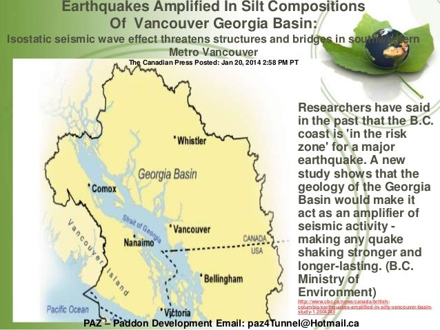
So, let us take a closer look at those earthquake-amplifying, sedimentary filled, "bowls-of-rock" which are beneath Seattle and other cities in the region. For those who have a relatively good grasp on maps, an image, linked here, shows the general contour of the rock-bowls which reside beneath the Seattle and Everett areas. Then, looking at the "much bigger picture" in the Cascadia region, a page linked here, shows the 40 to 60 kilometer deep Georgia Basin of northwest Washington and southwest British Columbia. This is a huge earthquake-amplifying basin which is filled with "soft glacial sediments and sedimentary rocks." An image and text, which are linked here, agree with this conclusion.

In all of this, there is something to consider. In the Cascadia region, there are many areas where buildings and other structures are built on sedimentary-type fill materials, which reside above harder bedrock. California also has many places where sedimentary-type materials are all that is supporting buildings and other structures. These materials can lose their strength and even experience serious liquefaction in a massive earthquake. This type of situation can allow even strongly built buildings and structures --- including bridges --- to tip sideways, fall over or simply collapse.

Looking into the Portland, Oregon area, regarding another matter, a KGW.com page, linked here, speaks of damage which likely could happen to the Interstate Bridge over the Columbia River, between Portland and Vancouver. It declares: "In a major quake, the drawbridge towers holding the counterweights would buckle, sending giant blocks of concrete into a free fall. That counterweight would come down just like a hammer, smashing through the bridge deck." But, there is more to this story.

Those falling counterweights would thoroughly smash any vehicles and people which happen to be on the roadway beneath them. Other vehicles may also slam into the concrete weights at freeway speed, as the large weights hit the roadway. The carnage in just this one area could be stunning, especially if it happened during a time of heavy traffic. Similar things could also happen in other cities in the Cascadia region, because of falling structures, etc. Seattle and other cities up and down the Pacific Coast and the inland Interstate-5 Freeway corridor all have their problems which make them rather vulnerable to great earthquakes.

Now, back to building on sedimentary materials and the Portland, Oregon area. Along the Willamette River, on a thick layer of sedimentary fill, is the six mile long, Critical Energy Infrastructure Hub (CEI). This is a six-mile stretch of fuel storage tanks and refineries, located right next to the Willamette River. What is worse, all this infrastructure is built on top of soft, sedimentary materials (link). The CEI holds a 3 to 5 day supply of petroleum products for the state of Oregon. In a massive earthquake, storage tanks may rupture and a large share of this stored fuel may be spread downstream in the Willamette and Columbia river systems. Furthermore, this fuel could be on fire. Up in the Puget Sound region of Washington state exists similar vulnerabilities, in the event of a massive quake.

Along the rivers and waters in many areas of the Pacific Northwest, and even in British Columbia, Canada, are many residential, commercial and industrial structures built on soft, earthquake-vulnerable, sedimentary materials. Research indicates that possibly the region around Seattle, Washington and Vancouver, British Columbia is no better off than Mexico City, in this regards (1)(2). The same holds true for may other cities of the Pacific Northwest region, and even in California, which are built near and along waters, or even on filled, swampy areas.

Let us now begin comparing who may actually have things worse. The recent Mexico earthquake was only an M7.1. A Cascadia earthquake, on the other hand, if it unleashes its full potential, could possibly be greater than an M9.2. That means a Cascadia quake at its full potential could be about 1000 times stronger than the recent quake in Mexico, and that quake in Mexico did a lot of damage. Therefore, in Cascadia, it may be wise to prepare for unimaginable damage and destruction --- along with numerous injuries and deaths, more than you would ever like to think about.

Looking further, after a massive West Coast seismic event, it may be wise to plan on surviving basically on your own for an extended period of time --- possibly even much longer than just two weeks. Those who have not properly prepared may be of little or virtually no use to anyone, especially to themselves, in this type of situation.

Let us now look at one particular location in southeastern California, to see their predicament. Let us consider the vulnerability of people and structures around the Salton Sea and surrounding region. Let us begin, by once again stating that much of Mexico City is built on layers of sand and clay which are up to 100 yards (or, up to 300 feet) deep. Remember this depth of sedimentary material, as we continue with this discussion. That depth of sedimentary material beneath Mexico City is very minor compared to the depth of sedimentary materials which exists in the Salton Trough --- in that area from the tip of the Gulf of California, northward, through the Colorado River Delta and Mexicali Valley in Mexico, plus the Imperial and Coachella valleys in California.

Almost one-third of the way down a page, linked here, is information on the Salton Trough. It states: "This formation, sediment nearly 9 miles deep, can trap earthquake energy and amplify seismic waves, resulting in longer, more intense shaking." Furthermore, in this area, people "live a couple of hundred feet below sea level with a 30 foot high pile of sand between you and the ocean." And yes, there is something else to think about.

If there is truly anywhere remotely near 9 miles deep of silt and sand beneath this area in which people live, it could potentially become rather unstable and possibly even somewhat movable, during a massive earthquake in the trough. In a state of severe and extended shaking, could this rather weak, sandy and sedimentary material still hold back the waters of the Gulf of California, which are a couple of hundred feet above the surface of the Imperial and Coachella valleys?

It is good to have at least a second or third opinion when looking at things like what is being dealt with, geologically, in a particular region and the depth of sedimentary materials which are presently all that is holding up your house or other structures --- especially when it is seismically-vulnerable sedimentary materials. A page on the San Diego State University (SDSU) website, linked here, states the following:

"The Gulf of California and the Salton Trough are components of a single geologic structure that averages less than 100 miles in width yet is more than 1,000 miles long. In this context, the Salton Trough is considered the landward extension of the Gulf. This point becomes clear when one considers that the Salton Valley exists only because the Colorado River delta is a natural earthen dam that completely excludes the waters of the Gulf. If it was not for that dam, the Valley would be submerged as far north as Indio."

The SDSU page also states: "The basement rocks under the north end of the Gulf are covered by as much as 25,000 to 30,000 feet of these deltaic sediments [from the Colorado River]." Well, 25,000 to 30,000 feet of sediments is only about 5 to 5-1/2 miles of seismically-shaky sedimentary materials --- which is far less that the 9 mile thickness of sediments noted in the page linked further above. But, even 5 to 5-1/2 miles of seismically-shaky sedimentary materials in much more than the mere "up to 300 feet" of sedimentary materials beneath Mexico City. So, it appears that people in the southeastern region of California could potentially be in a worse predicament.

A page associated with the University of California, Santa Barbara, linked here, states that "at the head of the Gulf of California, including the Salton Trough," there is "a vertical thickness of about 6,000 m (20,000 ft) of young sediments, mainly derived from ancestral Colorado rivers, has accumulated on spreading quasi-oceanic floor as the gulf has opened." Okay, so 20,000 feet of sediments in the Salton Trough is still about 66 times deeper in those seismically-shaky materials than that mere 300 feet of unstable sedimentary materials beneath Mexico City. And, just look at what has happened to Mexico city during serious earthquakes, over the years. Yes, there has been a lot of destruction and many people have died. So, what could it by like in southeastern California, if a massive earthquake were to hit in that region?

A Southern California Earthquake Center page, linked here, presents information relating to "the sedimentary basin in the Salton Trough, southern California." An earthquake simulation was done on a structural model of the Salton Trough. What did it show? The page states: "These simulations indicate that great amplification will occur during large earthquakes in the region due to the low seismic velocity of the sediments and the basin shape and depth." Further information relating to the seismic hazard in the Salton Trough region is found in a page linked here.

The writer wishes you all the best in the days ahead. Do yourself a favor and get properly prepared as quickly as you can. Nature waits for no one!


For further reading:

Current Expectations for a Cascadia Mega-Quake
https://cascadian.neocities.org/cascadiaquake.htm


Saturday, September 2, 2017

Yellowstone and the Cross Country Rift

The Yellowstone Supervolcano has been in the news lately (link). It is noted that the earthquake swarm now happening at Yellowstone is one of the largest ever recorded. But, there is one thing that this sporadic blogger has noted about the Yellowstone hotspot.

An article from the December 17, 1981 edition of the Spokane Daily Chronicle, which is linked here, includes a map which indicates the general location of a large (or rather, very large), ancient rift. This ancient rift cuts diagonally across the United States --- from the state of Georgia to the state of Washington. Now, there is something worth noting on this map.

Look at the state of Wyoming (WYO.) on this map. Observe how the diagonal line (the general location of the great rift) passes through the northwest corner of the state of Wyoming. So, what is important about this northwest corner of Wyoming. Yes, that is the location of Yellowstone National Park --- or more clearly, the Yellowstone Supervolcano.

To this sporadic blogger, it does appear that the Yellowstone Supervolcano may, in some way, be associated with the giant cross country rift. It appears that the Yellowstone Supervolcano is associated with this zone of weakness which extends deep into the continental crust. But, there is more to this story. From Yellowstone, this cross country rift (or zone of weakness) heads generally northwest, into the state of Washington.

Now, the blogger's research has led him to believe that the giant rift in Washington state continues in its westerly course, beneath the thick basalt flows of the Columbia River Lava Plateau. The blogger believes that the giant rift then exits the continental landmass on the west side of the Cascade Mountains in the form of that deep submarine canyon called the Strait of Juan de Fuca.

Once again, let us note that, from the blogger's research, it appears that the zone of weakness (the giant rift) extends from the Yellowstone Supervolcano to the Strait of Juan de Fuca. Now for some questions.

Should the Yellowstone Supervolcano experience a massive earthquake or a huge eruption, could it trigger a Cascadia Megaquake as a result of energy transferred via the giant rift? On the other hand, could a massive Cascadia Megaquake, as a result of energy transferred via the giant rift, trigger a devastating Yellowstone Supervolcano eruption?


For further reading:

Current Expectations for a Cascadia Mega-Quake
https://cascadian.neocities.org/cascadiaquake.htm