Let us now discuss just a bit further about that ancient rift, which is noted in the previous post from Wednesday, August 7, 2016. After this, the writer will do his best to refrain from further posts dedicated to this deeply buried rift. Let us begin this discussion by looking at information about rift systems in general.
A Wikipedia entry on Rifts, linked here, declares: "In geology, a rift is a linear zone where the Earth's crust and lithosphere are being pulled apart and is an example of extensional tectonics." The entry also declares: "The axis of the rift area may contain volcanic rocks, and active volcanism is a part of many, but not all active rift systems." As we continue through this discussion, keep in mind that "active volcanism is a part of many" rift systems. Considering this matter further, volcanism, in many cases, appears to be associated with extensional tectonics in rift systems, or where things are obviously weakening and spreading below the surface of the ground.
A map, linked here, gives a general illustration of the worldwide, mid-ocean ridge and rift system. Toward the center of the map is found the portion of the ridge and rift system called the "East Pacific Rise." Note that this oceanic rift system burrows into the mainland of North America at the northern end of the Gulf of California. This is shown clearly on a map, linked here.
A webpage (with illustrations), linked here, declares: "The Gulf of California sits at the northernmost end of an immense underwater mountain range called the East Pacific Rise, which extends across the Southeastern Pacific Ocean almost to Antarctica. Along much of this mountain range, lava wells up from below, causing the Earth's crust to split apart, and forming what geologists call 'spreading centers.'" From what is said on the page, it appears that volcanic activity is often associated with these "active spreading centers." As a side note, the page mentions a cause for transform faults which are associated with these spreading centers.
The page, linked above, declares that "the East Pacific Rise is a 'divergent' plate boundary, where huge slabs of the Earth's crust (plates) are moving away from each other." It states further that "near the Gulf of California, the relative motion of the plates changes so that the two plates (the North American Plate and the Pacific Plate) are moving sideways, sliding past one another." It is important to note that between the areas where the plates are sliding sideways past each other, there are short sections in which things are spreading apart. These are basically more localized spreading centers.
Looking further at the page linked above, it speaks of lava welling up from below. It appears this welling up of lava occurs at the spreading centers. Therefore, it is reasonable to believe that a line of volcanoes across a given region tells a story about the geology deep underground, plus indicates where there may be spreading centers, even localized spreading centers, on a given rift system. Let us now consider this matter further.
An obvious line of volcanoes appears to indicate a zone of weakness or rifting. Looking at evidence elsewhere on this earth, one example of rifting and an association with volcanoes is the East African Rift. Information about this rift is found on a Wikipedia page, linked here. This Wikipedia page includes a basic map of the rift and "some of the historically active volcanoes" which are spaced along it. The map also shows volcanoes spaced along a rift in the Red Sea. Yes, an obvious line of volcanoes does appear to tell a story about rifting, or the separation of plates, which may be happening in association with a continental landmass.
A general map, linked here, shows volcanic provinces associated with the East African Rift and the rifting in the Red Sea. Another map, linked here, notes the general location of volcanoes along the zones of rifting. In the examples noted, it appears that there is a clear association between rift zones and lines of volcanoes.
Let us now get back to the subject of an oceanic rift system which burrows into North America at the northern end of the Gulf of California. Again, let us remember that volcanoes can be associated with spreading centers and can mark the location of a rift system below the surface of the ground. So, let us trace the line of many volcanoes northward across the landmass from the tip of the Gulf of California, all the way to the U.S. border in northern Washington.
The first volcano on land, at the northern tip of the Gulf of California, appears to be Cerro Prieto. A Wikipedia entry, linked here, notes that this volcano is located about 18 miles south-southeast of Mexicali, Mexico. The entry declares further: "The volcano lies astride a spreading center associated with the East Pacific Rise. This spreading center is also responsible for a large geothermal field which has been harnessed to generate electric power by the Cerro Prieto Geothermal Power Station." Considering this information, it is clearly seen that isolated spreading centers, located between sections of transform faults on this system which penetrates the continental landmass, can host volcanoes.
A map, linked here, notes the location of Cerro Prieto, in Mexico. Looking further north into the United States, the map notes the location of Salton Buttes. Regarding Salton Buttes, a Wikipedia entry, linked here, declares that "They are the only active volcanoes in Southern California, and are associated with the East Pacific Rise." So, where does the now deeply buried East Pacific Rise, with its isolated spreading centers and volcanoes, go from here?
A space shuttle photo of southern California, looking in a northwesterly direction, is linked here. A line indicating the San Andreas fault is superimposed on this photo. Look at how the San Andreas takes off sharply to the west from the area of the Salton Sea. Then near Los Angeles, the fault takes a sharp turn to the north. Since we are considering rift systems, spreading centers and volcanoes, let us look at what another page states.
A webpage, linked here, states: "A volcano is an opening in the earth's crust that allows molten rock from the mantle to flow out onto the surface as lava." But, when considering volcanoes, there is something to note about the San Andreas Fault (SAF) system. The page states: "The SAF is a transform plate boundary (strike slip fault) and so is not accompanied by volcanic activity." So, if the San Andreas fault system does not host volcanic activity, where must we look to find those deeply buried, isolated spreading centers along the concealed, ancient rift system -- that north-trending rift system which was discussed in the previous post from Wednesday, September 7, 2016?
For a moment, let us diverge from the matter of that deeply buried, north-trending rift system. There appears to be a very logical explanation for the San Andreas fault system, which is not associated with the path of the below-continent rift system. Information relating to this matter may be discussed in a later post. Now, back to our search for a logical path for the buried rift system.
In the space shuttle photo of southern California, linked further above, there is something which is worth noting. From the Salton Sea, a more direct path for the now deeply buried remnants of the East Pacific Rise and its associated spreading centers would be to the east of the Sierra Nevada. Let us now consider if there are any indications that this could be the actual path of this buried rift.
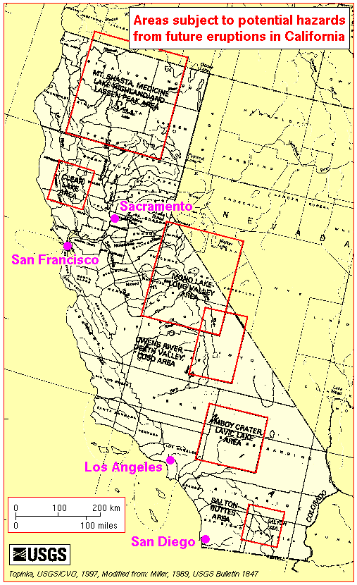
A map, linked here, is titled 'Volcanoes and Volcanic Areas of California.' Note that almost all the volcanoes in California are in a line along the eastern side of California -- in that area which sits to the east of the Sierra Nevada. Another map, linked here, is titled 'Areas subject to potential hazards from future eruptions in California.' Note once again that the bulk of this predicted volcanic activity is in the eastern part of California, to the east of the Sierra Nevada. To the writer, this indicates a line of isolated spreading centers, which are located below the surface of the ground in eastern California.
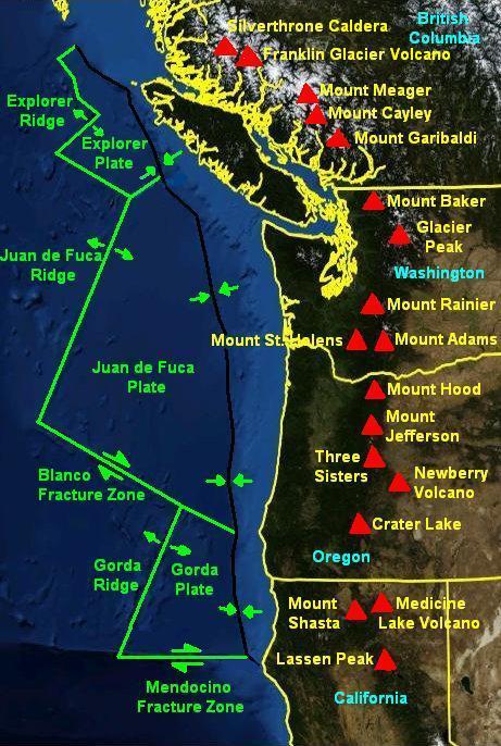
In the western United States, the major line of volcanic activity extending northward from the Gulf of California generally follows the eastern side of California. The line then intersects with Lassen Peak and Mount Shasta. From that point, the line continues northward in Oregon and Washington along the volcanoes of the Cascade Mountains. This line of volcanoes, which extends into Canada, is clearly shown on a map linked here.
Once again, there is only one statement which can reasonably be made. When things really cut loose in the Cascadia region, and possibly even in California, then many questions about this ancient, deeply buried rift will hopefully be answered.
For further reading:
Current Expectations for a Cascadia Mega-Quake
https://cascadian.neocities.org/cascadiaquake.htm
No comments:
Post a Comment