There is an old saying about a wise man who built his house on a rock. Then there was another man who built his house on sand. When the storms came, the house on the rock stood firm, but the house on the sand fell, and great was its fall. With this short introduction, let us begin to examine the Seattle Fault and potential earthquakes effects. It must be noted that the information in this post regarding sedimentary or fill material, and earthquake effects, can also apply to many other areas of the Pacific Northwest, plus elsewhere.
Maps linked here, here, and here show the general location of the east-west-trending Seattle Fault Zone. A LiveScience webpage, linked here, indicates that when a big quake breaks loose on the Seattle Fault, there could be certain areas which experience intense ground shaking, above and beyond adjoining areas. Why is this?
A webpage from the 1990s, linked here, indicates that to the south of the Seattle Fault is "surface bedrock." But to the north of this fault is "a half-mile-deep deposit of glacial sediments," and below the sediments is finally bedrock. This is what was known in the 1990s. A more up to date Wikipedia page on the Seattle Fault, linked here, presents a little different picture. It shows that south of the Seattle Fault, the basalt has been uplifted. In the Seattle Basin, to the north of the fault, it shows that the bedrock "is buried under at least 7 km (4.3 miles) of relatively softer, lighter sedimentary strata..."
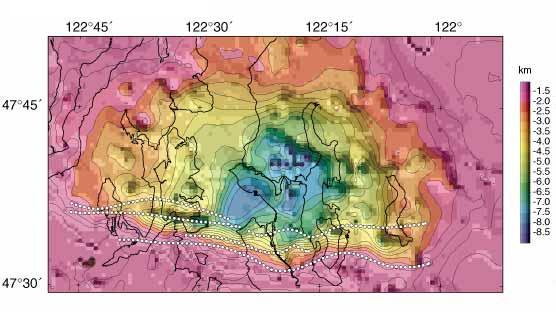
An image, linked here, shows "depths to the basement interface of the Seattle basin, with map and Seattle fault zone lines superimposed (link)." That is a very deep and very big pocket in the bedrock below Seattle. That deep pocket is filled in with softer materials. No matter which way you want to look at it, that is a very deep layer of softer, sedimentary-type material filling that big pocket in the bedrock in the Seattle Basin.
It is this deep pocket of softer, sedimentary material to the north of the Seattle Fault which raises a concern. A webpage, linked here, is titled 'Earthquake-Magnifying Pocket Beneath Seattle Seen in New Detail.' The page states: "The deep basin that lies beneath Seattle is a source of seismic worry
for scientists because the shape and material of the basin amplify
ground shaking." The seismic waves can also "become focused into a particular area." That could be very damaging.
To complicate things, a large area around where the Kingdome formerly stood, and around the southern end of the Alaskan Way Viaduct is built on a tidal flat. This tidal flat was filled-in with poorly packed materials by Seattle's founders. A map, linked here, shows the rather large areas of artificial fill and other softer materials in the Seattle area. A map, linked here, shows the seismic hazards in the Seattle area. Note how the highest seismic hazards are generally in the areas of artificial fill.
In a massive earthquake, fill and softer sedimentary materials can lose their strength and shake like Jell-O, or possibly even worse. The process of liquefaction, which can occur during a massive earthquake, may allow heavy structures to sink in these softer materials. Heavy structures which sink could be things like bridges and buildings. It could also mean piers which are built on fill material and possibly even things like seawalls.
Regarding the effect of seismic waves on various materials, a webpage by the Pacific Northwest Seismic Network (PNSN), linked here, declares: "Seismic waves travel faster through hard rocks than through softer rocks and sediments. As the waves pass from deeper harder to shallow softer rocks the [sic - they] slow down and get bigger in amplitude as the energy piles up. The softer the rock or soil under a site is, the larger the wave. Softer soils amplify ground motion." The page also indicates that thick layers of softer or sedimentary materials "can lead to both higher amplitudes and longer durations of shaking."
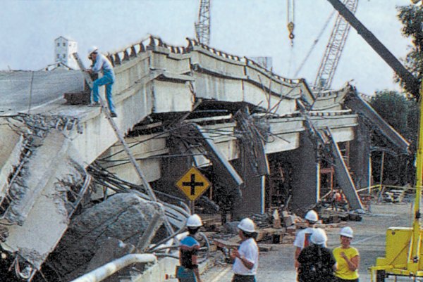
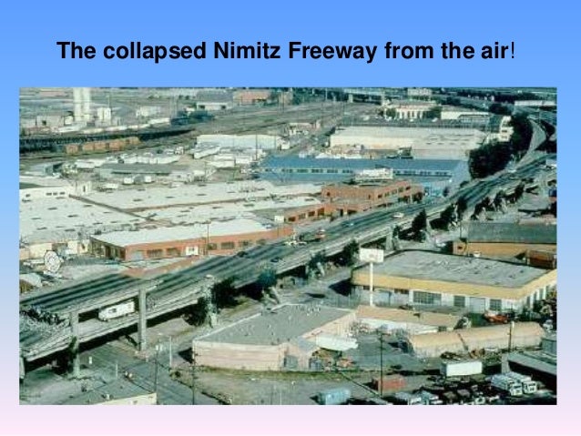
A good example of increased shaking because of softer materials is the Nimitz Freeway (Cypress Street Viaduct) in Oakland, California. This double-decker freeway (which was similar in design to the Alaskan Way Viaduct) collapsed in the 1989 Loma Prieta earthquake (pic-1) (pic-2) (pic-3). Why? Partly because of its design, but, possibly to a greater degree, because it "was built on landfill mud, which amplified the concrete's shaking 800 percent." So, from the looks of it, to the north of the Seattle Fault in the basin, there could be some intense and relatively long-lasting shaking during a major earthquake event.
A July 2015 article, linked here, declares: "...Scientists say the Seattle fault is dangerous not just because of its location, running right through a major metropolitan area, but also because of its depth. It's right at the earth's surface." If the Seattle Fault were to experience a major rupture, it could potentially be "the worst seismic disaster in the country." A 150-page report portrayed "what a magnitude 6.7 earthquake on the Seattle fault would look like." The report considered things like destroyed buildings, plus injuries and deaths. It considered damage to transportation routes and ports, among other things. The findings of that report were said to be "chilling."
It is now time for some even more chilling "food for thought." An earthquake on the Seattle Fault with a magnitude of only 6.7 was shown to be very devastating. But, what would be the results if a much deeper rift in the region (of which there appears to be at least two) were to rupture and the Seattle Fault were to "link up" in the massive quake event, producing simultaneous quakes and a higher overall magnitude event? What could be the final effects of such an event on Seattle?
For those new to the subject of linked faults and simultaneous earthquakes, plus the increase in overall magnitude produced, the following links provide a basic introduction:
(1) - "...On occasion these faults can link up into much larger earthquakes."
(2) - "...A nearly simultaneous strong earthquake accompanied the initially recognized temblor.
(3) - "Before the shaking from one earthquake ends, shaking from another might begin, amplifying the effect of ground motion."
(4) - "The earthquake started along the San Jacinto Fault and continued its way upward toward the San Andreas Fault, before both came together to make one giant 7.5 magnitude earthquake.
For further reading:
Current Expectations for a Cascadia Mega-Quake
https://cascadian.neocities.org/cascadiaquake.htm
No comments:
Post a Comment